Wiki Article
Ketzin
Nguồn dữ liệu từ Wikipedia, hiển thị bởi DefZone.Net
Ketzin | |
|---|---|
 Town hall | |
 Coat of arms | |
Location of Ketzin
within Havelland district  | |
 Location of Ketzin | |
 Ketzin  Ketzin | |
| Coordinates: 52°28′11″N 12°50′42″E / 52.46972°N 12.84500°E | |
| Country | Germany |
| State | Brandenburg |
| District | Havelland |
| Government | |
| • Mayor (2022–30) | Katrin Mußhoff[1] (SPD) |
| Area | |
• Total | 93.64 km2 (36.15 sq mi) |
| Elevation | 32 m (105 ft) |
| Population (2023-12-31)[2] | |
• Total | 6,758 |
| • Density | 72.17/km2 (186.9/sq mi) |
| Time zone | UTC+01:00 (CET) |
| • Summer (DST) | UTC+02:00 (CEST) |
| Postal codes | 14669 |
| Dialling codes | 033233 |
| Vehicle registration | HVL |
| Website | www.ketzin.de |
Ketzin (German: [kɛˈtsiːn] ⓘ, official name: Ketzin/Havel) is a town in the Havelland district, in Brandenburg, Germany. It is situated on the river Havel, 17 km northwest of Potsdam, and 40 km west of Berlin.
History
[edit]Ketzin was first mentioned in 1197 by a document. Until 1571, Ketzin was kept in the Bishopric of Brandenburg, the imperial principality of the Prince-bishop of the Diocese of Brandenburg and according to the law, not part of the Margraviate of Brandenburg.[3]
Demography
[edit]-
 Development of Population since 1875 within the Current Boundaries (Blue Line: Population; Dotted Line: Comparison to Population Development of Brandenburg state; Grey Background: Time of Nazi rule; Red Background: Time of Communist rule)
 -
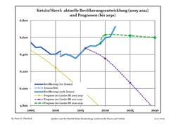 Recent Population Development and Projections (Population Development before Census 2011 (blue line); Recent Population Development according to the Census in Germany in 2011 (blue bordered line); Official projections for 2005–2030 (yellow line); for 2017–2030 (scarlet line); for 2020–2030 (green line)


Ketzin/Havel: Population development within the current boundaries (2020)[4] | ||||||||||||||||||||||||||||||||||||||||||||||||||||||||||||||||||||||||||
|
|
| ||||||||||||||||||||||||||||||||||||||||||||||||||||||||||||||||||||||||
Geography
[edit]The town counts 6 Ortsteile (civil parishes): Etzin, Falkenrehde, Knoblauch, Paretz, Tremmen and Zachow.
Transport
[edit]The Ketzin Cable Ferry, a vehicular cable ferry, crosses the Havel between Ketzin and Schmergow.
References
[edit]- ^ Landkreis Havelland Wahl der Bürgermeisterin / des Bürgermeisters. Retrieved 3 July 2024.
- ^ "Alle politisch selbständigen Gemeinden mit ausgewählten Merkmalen am 31.12.2023" (in German). Federal Statistical Office of Germany. 28 October 2024. Retrieved 16 November 2024.
- ^ Abb, Gustav; Wentz, Gottfried, eds. (1929-12-31). "Das Bistum Brandenburg, Teil 1". doi:10.1515/9783111574356. hdl:11858/00-001S-0000-0022-D47D-E.
{{cite journal}}: Cite journal requires|journal=(help) - ^ Detailed data sources are to be found in the Wikimedia Commons.Population Projection Brandenburg at Wikimedia Commons
External links
[edit]![]() Media related to Ketzin/Havel at Wikimedia Commons
Media related to Ketzin/Havel at Wikimedia Commons
Towns and municipalities in Havelland | ||
|---|---|---|
 | ||
| International | |
|---|---|
| National | |
| Geographic | |
This Brandenburg location article is a stub. You can help Wikipedia by adding missing information. |