Wiki Article
Saksun
Nguồn dữ liệu từ Wikipedia, hiển thị bởi DefZone.Net
Saksun | |
|---|---|
Village | |
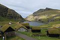
.JPG) View of Saksun from the lake | |
 Saksun Location in the Faroe Islands | |
| Coordinates: 62°14′56″N 7°10′33″W / 62.24889°N 7.17583°W | |
| State | |
| Constituent country | |
| Island | Streymoy |
| Municipality | Sunda |
| Population (1 January 2006) | |
• Total | 9 |
| Time zone | GMT |
| • Summer (DST) | UTC+1 (EST) |
| Postal code | FO 436 |
| Climate | ET |
Saksun is a village near the northwest coast of the Faroese island of Streymoy, in Sunda Municipality.
Geography
[edit]Saksun lies in the bottom of what used to be an inlet of the sea, surrounded by high mountains. The inlet formed a good deep natural harbour, until a storm blocked it with sand. The old harbour become an inaccessible seawater lagoon, only accessible by small boats on high tide.
Facilities
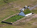
[edit]The village has a heritage farm called Dúvugarðar and a church. The church was originally built in Tjørnuvík, but in 1858 it was disassembled, carried over the mountains and reassembled in Saksun. The Museum occupies a seventeenth-century farm house called Dúvugarður. The house belongs to the Dúvugarður farm which is still an active sheep farm with approximately 710 ewes.
Gallery
[edit]-

-
 Church.
 -
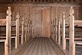 Interior of church
 -
 Church
 -
 The old farm
 -
 Saksun, Postverk Føroya
 -
 Down to the beach
 -
 Saksun
 -
 West coast
 -
 Beach
Beach


.JPG)


.JPG)
See also
[edit]External links
[edit]- Faroeislands.dk: Saksun Images and description of all cities on the Faroe Islands.
- Guide to Faroe Islands: Saksun
| International | |
|---|---|
| National | |
This Faroe Islands location article is a stub. You can help Wikipedia by adding missing information. |