Wiki Article
Sophene
Nguồn dữ liệu từ Wikipedia, hiển thị bởi DefZone.Net
| Sophene Ծոփք Provincia Sophene | |
|---|---|
| Province of the ancient kingdom of Armenia | |
| 189 BC–530 AD | |
 | |
| Sophene in the south-west of the Kingdom of Armenia (spelled "Dzopk" in the Western Armenian dialect). | |
| Capital | Carcathiocerta (Eğil), later Arshamashat (Elazığ) |
| History | |
• Artaxias I declaring himself independent | 189 BC |
• Included in the province of Armenia | 530 AD |
Sophene (Armenian: Ծոփք, romanized: Tsopkʻ or Չորրորդ Հայք, lit. 'fourth Armenia'; Ancient Greek: Σωφηνή, romanized: Sōphēnē) was a province of the ancient kingdom of Armenia, located in the south-west of the kingdom, and of the Roman Empire. The region lies in what is now southeastern Turkey.[1]
Etymology of the Name
[edit]Tsopk appears as a province of the Fourth Armenia of Greater Armenia, which was so powerful that Strabo and other ancient historians called it a small kingdom[2].
“Its authority was so great that Strabo called it a small kingdom”[3].
In the southwestern part of the Armenian Highlands, in the land of Tsopk, state formations are mentioned starting from the beginning of the 2nd millennium BC, which in ancient written sources are known as Tsupana, Isuwa, Sopah, Suba, Tsupani, Sophene and other names[2].
Geography
[edit]The Fourth Armenia extended in the regions of the upper Western Tigris and the lower course of the Aratsani. In the north, northeast and east it bordered High Armenia, Turuberan and Aghdznik, in the south it was separated from Mesopotamia by the Masios mountains, and in the west, by the Euphrates river, it bordered Lesser Armenia and Cappadocia[4]. The relief of the Fourth Armenia is diverse. There are both high mountain ranges, river valleys and plains. It is entirely irrigated by the Western Tigris and the Aratsani. The climate is also diverse. The southern part, south of the Armenian Taurus, has a dry subtropical climate, whereas the northern part has a temperate climate and receives sufficient precipitation[5].
Natural Resources
[edit]The analysis of metal objects discovered in several large settlements located in the territory of Tsopk has made it possible to propose a hypothesis according to which this region in the 3rd millennium BC was at a much higher level of metallurgy compared to the states of Mesopotamia[6]. In terms of agricultural lands, the conditions are very favorable in western Tsopk of the Armenian Highlands, where they amount to about 550 sq km[7]. The soil of Tsopk is fertile and well supplied with relatively abundant rivers and atmospheric precipitation[8]. Particularly fertile lands in the Fourth Armenia are the plains of Kharberd and Balhovit. The northern mountainous regions are rich in forests and known for deposits of oil, copper, lead and silver. Its copper, lead and silver mines have been known since ancient times and were exported in considerable quantities. Deposits of non-ferrous metals are mainly located in the valley of the Arghana river, one of the tributaries of the Western Tigris[9].
Kingdom of Tsopk (Sophene)
[edit]The expansion of the spatial perception of Tsopk was undoubtedly connected with the emergence of the Kingdom of Tsopk, which took place in the middle of the 3rd century BC. From the fragmentary information that has reached us, it can be assumed that in the southeast it extended as far as the Kaghirt River, included up to the Masios Mountains and the regions lying to their south near the Euphrates, and in the northwest — the surroundings of Melitene and Commagene.[10]
The Kingdom of Tsopk or Sophene was a Hellenistic state located between Greater Armenia and Syria[11]. The kingdom ruled by the Orontid dynasty was culturally mixed, combining Greek, Armenian, Iranian, Syrian, Anatolian and Roman influences[12]. Founded around the 3rd century BC, the kingdom remained independent until 95 BC, when the king of Greater Armenia Tigran II conquered the territories and incorporated them into his empire. Tsopk was the first state in the region to mint its own coins[13].
The Armenian kingdom of Tsopk (Armenian: Tsopk) originated in the 3rd century BC in the historical region of Tsopan. Before the collapse of the Seleucid Empire it included Commagene, forming with it a unified kingdom, whose rulers traditionally descended from a junior branch of the Orontid dynasty. One of the first kings of the united state is mentioned as Sam I (Samos, Sames), who founded the city of Samosata on the Euphrates[14].
Initially, the kingdom depended on the Seleucid Empire[15], to which it belonged as a special satrapy, was obliged to pay tribute and provide troops, but it was governed by local hereditary dynasts (kings), enjoyed internal autonomy and sometimes completely freed itself from Seleucid domination. In the mid-3rd century BC, Tsopk was ruled by the successor of Samus I, King Arsham (Arsames). He was one of the first Armenian rulers to mint his own coins. On the left bank of the Aratsani river, a tributary of the Euphrates, he founded the city of Arshamashat (Arsamosata). Around 240 BC, Arsham tried to declare himself an independent king, but failing to achieve his goal, he submitted to Seleucid rule. His son Xerxes inherited the throne from him[16].
Upon coming to power, Xerxes refused to pay tribute to the Seleucid treasury. In response, Antiochus III besieged the capital of Tsopk, Arshamashat. As a result of negotiations, the conflict was resolved: Antiochus, marrying his sister Antiochis to the rebellious Armenian king, forgave his debt, and Xerxes, in turn, recognized Seleucid authority. However, after some time Antiochis killed her husband Xerxes and annexed the kingdom of Tsopk to her brother’s domains[17].
The capitals of the Kingdom of Tsopk, Arshamashat and (K) Arkathiokert, were among the most notable and commercially prosperous cities of Armenia, which continued to preserve their significance within the Kingdom of Greater Armenia for several more centuries[18].
Foundation of a New Royal Dynasty
In 200 BC, after the murder of Xerxes, Antiochus appointed Zareh from the Orontid dynasty as ruler of Tsopk. At the same time, the Seleucid leader appointed Artashes to a similar position in Greater Armenia. Although there is no precise evidence, the fact that the latter’s father was also named Zareh (Zariadr) suggests that the two Armenian rulers were father and son. In 190 BC, after the defeat of the Seleucid army in the Battle of Magnesia, Greater Armenia and Tsopk gained independence. Their kings, Artashes and Zareh, became the founders of the Artaxiad and Shakhuni dynasties. By the Treaty of Apamea in 188 BC, which secured Rome’s victory over the Seleucids, the Roman Senate recognized the independence of the Armenian kingdoms. Thus, in addition to the recognition of independence by the Romans, this treaty also marked the first legal contact between Armenia and Rome. Apparently, around the same time Commagene also gained independence, separating from Tsopk: at least by 162 BC it is already mentioned by Diodorus Siculus as a separate kingdom under Ptolemy[19].
The newly independent Armenian states had a significant free peasantry, which formed the basis for army formation, which ultimately allowed Armenian kings to pursue an active expansionist policy. Over time, Greater Armenia and Tsopk, conquering a number of regions, significantly expanded their borders[20].
In 94 BC (or 95 BC), the king of Greater Armenia Tigran II captured Tsopk and executed its king Yervand V. After the capture and execution of the king, the Armenian kingdom of Tsopk, becoming part of another Armenian kingdom, ceased to exist.[20]
Economy
[edit]The kingdom was distinguished by its fertile lands; Polybius called its central part nothing less than the “Beautiful Plain.” Among all Armenian regions, Tsopk was the most involved in international trade. A major caravan route, the so-called former “royal road,” passed through its territory, stretching from Asia Minor to Media, Parthia, and Bactria. South of Tsopk, the trade route from eastern Iran through Seleucia to Antioch passed through northern Mesopotamia. All the most important trade connections of Armenia passed through Tsopk, which was located near major trade and cultural centers. Active trade took place in the cities of Tsopk, which in turn led to the introduction of monetary circulation there earlier than in other Armenian lands and to the beginning of local coin minting. The mint was located in the capital of the kingdom, Arshamashat. Today there are numerous collections of coins minted by Armenian rulers of Tsopk, starting from the mid-3rd century BC[21].
Coins
[edit]Coins of the kings of Tsopk are extremely rare. Some of these coins include:[22]

Coins minted during the reign of King Samos
King Samos
Arsham I
Two chalkoi – club of Dionysus[22]

Coins minted during the reign of King Arsham I:
Two chalkoi – horseman and infantry soldier
Two chalkoi – horseman and lion
Four chalkoi – horseman and lion

One chalkous – horse head
One chalkous – winged thunderbolt
One chalkous – horseman and infantry[23]
Coins minted during the reign of King Arsham II:

Arsham II
Four chalkoi – horseman
Two chalkoi – horseman
Two chalkoi – standing nude figure[24]
Coins minted during the reign of King Xerxes:
King Xerxes
One chalkous – Victory
Two chalkoi – Athena seated
Two chalkoi – Athena standing
Coins minted during the reign of King Abdissares:
Four chalkoi – eagle standing to the right[25]
Administrative Division
[edit]According to the “Ashkharatsuyts,” Tsopk consisted of the following 10 provinces: Khordzyan (Khordzean) – center: Kogoberd, Hashtyank (Hashteank) – center: Ktharich, Paghntun – center: Paghin, Balhovit – center: Arshamshat, Lesser Tsopk (Tsopk Shahuneats) – center: Hierapolis, Andzit – center: Andzit fortress, Degik – center: Krni fortress, Gavrek (Gavrek) – center: Lusatharich, Angheghatun – center: Anggh, Greater Tsopk – center: Bnabeg[26]
Provinces
[edit]Khordzyan
It extended in the upper course of the Khordzyan river, mainly on its right side. It was mostly covered with dense forests and occupied part of present-day Dersim. Among its historical sites was the Artales fortress (also written Artaleson). Artales was located on the line of the first division of Armenia. This is why Justinian paid special attention to its fortification. It is likely that the settlement of Khozan, mentioned by Asoghik and Aristakes Lastivertsi as a city, was also located in this province[26].
Hashtyank
It extended along the right bank of the Aratsani. To the east it bordered the Taron province of Turuberan, and to the west the provinces of Khordzyan and Paghntun of the Fourth Armenia. Its territory corresponds to present-day Chapaghjur. Part of Hashtyank belonged to the junior branches of the Arsacid dynasty[26].
The notable historical-geographical site of the province was the Ktharich fortress. In the decree of Emperor Justinian and in Byzantine sources, it is called Kitharizon. During Justinian’s reign it was rebuilt and strengthened as a border fortress and became a Byzantine garrison station. Later, a small feudal town developed around it. The fortress occupied a dominant position over the surroundings, and water was brought into the city from afar. Many settlements in the province were fortified to protect against floods[26].
Paghntun
It was located south of Khordzyan on the right bank of the Aratsani. Its notable site was the Paghin fortress, now in ruins. Paghin was one of the strong fortresses of ancient Armenia. From this province came Hovsep, one of the “first translators” sent abroad for education by Sahak and Mesrop Mashtots[26].
Angheghtun
It extended east of Greater Tsopk in a mountainous region along the Zibene river, on the southern slopes of the Armenian Taurus. According to tradition, the mythical Torq Angegh originated from this province. It belonged to the Angeghatuni princely house. Its main fortress was Anggh, the residence of the Angegh princes. It is assumed that in ancient times this fortress was the center of an Armenian tribal union. There are indications that in the 4th century it temporarily passed into the hands of the Arsacid royal court[26].
Balhovit
This province corresponds to the region of present-day Balu, located in the valley of the Aratsani between Chapaghjur and Kharberd. It is a plain with fertile lands. The name of the province and its center, Balu, is connected with the ancient Bal or Bagh tribe. The notable site was the Balu fortress, which still exists as a small town on the right bank of the Aratsani. The other three provinces of the Fourth Armenia—Lesser Tsopk (Shahuneats), Degik, and Gorek—played a less significant role in political and economic life. The exact locations of Degik and Gorek are unknown. Shahuneats Tsopk is more frequently mentioned and corresponds to the region north of Kharberd[26].
Andzit (Andzith or Handzit)
This province has an ancient origin. It extended along the lower course of the Aratsani, mainly on the left bank, corresponding to the Kharberd region, known for its fertile lands.Notable sites include: Mazara – a city, probably located near mountain passes east of Lake Tsovk, along the “Royal Road.” It was an important station and fortress.Kharberd (Kharberd/Kharpout) – corresponding to modern Harput (Elazig), located on a plateau near the lower Euphrates. It was a strong fortress in the 10th–13th centuries.Randea (Hrandea) – located on the left bank of the Aratsani. In 62 AD, Armenian-Parthian forces defeated the Roman army here. In 63 AD, a treaty was concluded, marking the beginning of the Arsacid dynasty in Armenia.Some locations of the Fourth Armenia cannot be precisely assigned to provinces. Among them is Arshamashat, a major Hellenistic city and trade center, probably located in Handzit[26].
Greater Tsopk
This name came into use from around the 4th century, when Tsopk was divided into smaller provinces. It extended in the basin of the Arghana river and included parts of the Amida (Diyarbakir) region. In the late 6th century, Amida was separated and annexed to Mesopotamia.Notable sites include:Bnabeg – a fortress where royal treasures were kept in the 4th century.Arkathiokert – a major Hellenistic city and trade center.Arghana (Arzni) – corresponding to modern Ergani, rich in copper deposits.Amida – modern Diyarbakir, often confused with Tigranakert, but actually a different city located further northeast[26].
-
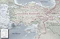
 Map showing Sophene right as it became a province of the ancient kingdom of Armenia under Tigranes the Great
 -
 Sophene and the other provinces of the ancient kingdom of Armenia
 -
-
 Roman dependency of Sophene (as of 31 BC)
 -
 Roman province of Sophene in the year 120
.svg)


See also
[edit]References
[edit]- ^ The History of Rome By Theodor Mommsen, William Purdie Dickson.
- ^ a b Հայագիտության հարցեր, հանդես 1 (19), ԵՊՀ հրտ․, Երևան, 2020, էջ 5։
- ^ Ինճիճեան Ղ., Ստորագրութիւն հին Հայաստանեայց, Վէնէնտիկ, 1822, էջ 47-51:
- ^ Թ.Հակոբյան, Հայաստանի Պատմական աշխարհագրություն, Երևան, 1984, էջ 211։
- ^ Թ.Հակոբյան, Հայաստանի Պատմական աշխարհագրություն, Երևան, 1984, էջ 211։
- ^ Ա․ Վ․ Քոսյան, Ե․ Հ․ Գրեկյան,Հայկական լեռնաշխարհի միջավայրային պատմությոնը, Երևան, 2024, էջ 98։
- ^ Ա․ Վ․ Քոսյան, Ե․ Հ․ Գրեկյան,Հայկական լեռնաշխարհի միջավայրային պատմությոնը, Երևան, 2024, էջ 118։
- ^ Ա․ Վ․ Քոսյան, Ե․ Հ․ Գրեկյան,Հայկական լեռնաշխարհի միջավայրային պատմությոնը, Երևան, 2024, էջ 91։
- ^ Թ.Հակոբյան, Հայաստանի Պատմական աշխարհագրություն, Երևան, 1984, էջ 211։
- ^ «Հայ ժողովրդի պատմություն», ՀԽՍՀ ԳԱ հրատ., հատ. Ա, Երևան, 1971, էջ 512։
- ^ A. E Tep-Саркисянц (2005). История и культура армянского народа: с древнейших времен до начала XIX в. Ереван. Ер с. 62.
- ^ Евгений Михайлович Жуков, Очерки истории СССР: Первобытно-общинный строй и древнейшие государства на территории СССР, Изд-во Академии наук СССР, 1956, с. 422-424.
- ^ Евгений Михайлович Жуков, Очерки истории СССР: Первобытно-общинный строй и древнейшие государства на территории СССР, Изд-во Академии наук СССР, 1956, с. 422-424.
- ^ Г. Тирацян, Страна Коммагена и Армения. Изд. академии наук Армянской ССР № 3, 1956, стр. 69-74.
- ^ Հայագիտության հարցեր, հանդես 1 (19), ԵՊՀ հրտ․, Երևան, 2020, էջ 5։
- ^ A. E Tep-Саркисянц (2005). История и культура армянского народа: с древнейших времен до начала XIX в. Ереван. Ер с. 62.
- ^ Дэвид Лэнг, Армяне — народ-созидатель, Москва, 2007, 152-154.
- ^ Ռ. Հ. Հարությունյան , Մեծ Հայքի վարչա-քաղաքական բաժանման համակարգն ըստ «Աշխարհացոյց»-ի, Մաս Ա, Երևան, 2001, էջ 114:
- ^ Г. Тирацян, Страна Коммагена и Армения. Изд. академии наук Армянской ССР № 3, 1956, стр. 69-74.
- ^ a b Дэвид Лэнг, Армяне — народ-созидатель, Москва, 2007, 159.
- ^ C.Т. Еремян, Основные черты общественного строя Армении в эллинистическую эпоху, Изд., академии наук Армянской ССР, № 11, 1948, стр. 33-74.
- ^ a b Եղիա Ներսէսեան, Ծոփքի հայ թագավորության դրաները (շուրջ 260-70 Ք․ Ա․), Բեյրութ, 2013, էջ 48։
- ^ Եղիա Ներսէսեան, Ծոփքի հայ թագավորության դրաները (շուրջ 260-70 Ք․ Ա․), Բեյրութ, 2013, էջ 49։
- ^ Եղիա Ներսէսեան, Ծոփքի հայ թագավորության դրաները (շուրջ 260-70 Ք․ Ա․), Բեյրութ, 2013, էջ 54։
- ^ Եղիա Ներսէսեան, Ծոփքի հայ թագավորության դրաները (շուրջ 260-70 Ք․ Ա․), Բեյրութ, 2013, էջ 48։
- ^ a b c d e f g h i Թ.Հակոբյան, Հայաստանի Պատմական աշխարհագրություն, Երևան, 1984, էջ 211։
|  | |
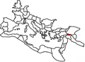
† Italy was never constituted as a province, instead retaining a special juridical status until Diocletian's reforms. | ||
| International | |
|---|---|
| Geographic | |