Collorec
| Collorec | |
 | |
| Verwàltung | |
|---|---|
| Land | |
| Region | |
| Département | Finistère (29) |
| Arrondissement | Châteaulin |
| Kànton | Carhaix-Plouguer |
| Kommünàlverbànd | Haute Cornouaille |
| Àmtliga Nàma | Collorec |
| Maire | Georges Croguennec (2014-2020)[1] |
| Code Insee | 29036 |
| Poschtlaitzàhl | 29530 |
| Iiwohner | |
| Iiwohner | 592 |
| Flech | 28,39 km2 |
| Bevelkerungsdicht | 23,46 Iiw./km2 |
| Làg | |
| Koordinate | 48° 17′ 11″ N, 3° 46′ 30″ W / 48.286388888889°N,3.775°WKoordinate: 48° 17′ 11″ N, 3° 46′ 30″ W / 48.286388888889°N,3.775°W |
| Heche | 141 m |
 Collorec Collorec (Frànkrich) | |
Collorec (bretonisch Koloreg) isch e franzesischi Gmai im Département Finistère in dr Region Bretagne.
D Gmai ghert zum Kanton Carhaix-Plouguer un zum Arrondissement Châteaulin.
Geografi
[ändere | Quälltäxt bearbeite]Collorec lyt 41 km vu Quimper un 54 km vu Brest uf ere Hechi zwische 72 m un 221 m iber Normalnull.
Gschicht
[ändere | Quälltäxt bearbeite]Collorec isch zum erschte Mol gnännt wore anne 1108 as Choloroc (1536 Collorec).
Verwaltig
[ändere | Quälltäxt bearbeite]Dr Maire vu Collorec isch dr Georges Croguennec. Collorec ghert zum Kommunalverband Haute Cornouaille.
Bevelkerigsentwicklig
[ändere | Quälltäxt bearbeite]| Johr | 1962 | 1968 | 1975 | 1982 | 1990 | 1999 | 2008 |
| Inwohner | 1.148 | 1.038 | 891 | 778 | 692 | 647 | 667 |
Dialekt
[ändere | Quälltäxt bearbeite]Dr traditionäll Dialäkt vu Collorec ghert zem Bretonisch.
Böuwärch
[ändere | Quälltäxt bearbeite]- Chilche Notre-Dame
- Kapäll Sainte-Marguerite
Bilder
[ändere | Quälltäxt bearbeite]-

Chilche Notre-Dame -
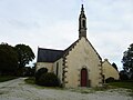
Kapäll Sainte-Marguerite -

Oratoire Sainte-Barbe -

Dotedänkmol


Weblink
[ändere | Quälltäxt bearbeite]Fueßnote
[ändere | Quälltäxt bearbeite]- ↑ Liste des maires au 25 avril 2014 (data.gouv.fr)