Lapoutroie
| Lè Peutraille | |
 Lè Peutraille | |
| Verwàltung | |
|---|---|
| Land | |
| Region | |
| Département | Haut-Rhin (68) |
| Arrondissement | Colmar-Ribeauvillé |
| Kànton | Sainte-Marie-aux-Mines |
| Kommünàlverbànd | Vallée de Kaysersberg |
| Àmtliga Nàma | Lapoutroie |
| Maire | Philippe Girardin (2014-2020)[1] |
| Code Insee | 68175 |
| Poschtlaitzàhl | 68650 |
| Iiwohner | |
| Iiwohner | 1.872 |
| Flech | 21,12 km2 |
| Bevelkerungsdicht | 89,68 Iiw./km2 |
| Làg | |
| Koordinate | 48° 09′ 09″ N, 7° 10′ 10″ E / 48.1525°N,7.1694444444444°EKoordinate: 48° 09′ 09″ N, 7° 10′ 10″ E / 48.1525°N,7.1694444444444°E |
| Heche | 421 m |
 Lè Peutraille Lè Peutraille (Frànkrich) | |
| Website | |
| http://www.lapoutroie.fr | |
| Dialäkt: Elsassisch |
Lè Peutraille (Patois, els. Buderej, frz. Lapoutroie, dt. Schnierlach) ìsch e frànzeesche Gmein ìm Owerelsàss ìn dr Region Grand Est (bìs 2015 Region Elsàss). D Gmein ghert zem Kanton Sainte-Marie-aux-Mines un zem Arrondissement Colmar-Ribeauvillé.
Gschìcht
[ändere | Quälltäxt bearbeite]Lè Peutraille ìsch zem erschte Mol gnannt worre ìm 12. Jh. àls Sconerloch (1288 lai Portaie).
Vun 1871 bìs 1918 hàt d Gmein zem ditsche Richslànd Elsàss-Lothringe ghert.
Verwàltung
[ändere | Quälltäxt bearbeite]Dr Maire vun Lè Peutraille ìsch dr Philippe Girardin. Lè Peutraille ghert zem Kommünàlverbànd Vallée de Kaysersberg.
Bevelkerungsentwìcklung
[ändere | Quälltäxt bearbeite]| Johr | 1962 | 1968 | 1975 | 1982 | 1990 | 1999 | 2007 |
| Inwohner[2] | 1601 | 1712 | 1810 | 1911 | 2000 | 2104 | 2049 |
Dialekt
[ändere | Quälltäxt bearbeite]Dr romànisch Dialekt vun Lè Peutraille ghert zem Welche un domìt zem Lorrain.
-
 Kirich Sainte Odile
 -
 Kirich z Hachimette


-
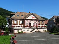 Mairie
 -
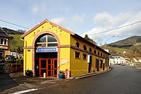 Musée des Eaux de Vie


Literàtür
[ändere | Quälltäxt bearbeite]- Michel Paul Urban: Lieux dits. Dictionnaire étymologique et historique des noms de lieux en Alsace. Édition du Rhin, Strasbourg 2003
Weblink
[ändere | Quälltäxt bearbeite] Commons: Lapoutroie – Sammlig vo Multimediadateie
- https://web.archive.org/web/20190901234918/http://lapoutroie.fr/
Referanza
[ändere | Quälltäxt bearbeite]- ↑ Liste des maires au 25 avril 2014 (data.gouv.fr)
- ↑ INSEE: Population et logements par commune depuis le recensement de 1962 (1961 pour les Dom) à 1999