سنت آلبنز
| St Albans | |
|---|---|
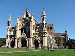
 View from the west in front of St Albans Cathedral | |
 Coat of Arms | |
| Area | ۶٫۹۹ sq mi (۱۸٫۱ km2) |
| جمعیت | ۵۷٬۷۹۵ (2011)[۱] |
| • Density | ۸٬۲۶۸/sq mi (۳٬۱۹۲/km2) |
| OS grid reference | TL148073 |
| • لندن | ۱۹ mi (۳۱ km)* SSE |
| District | |
| Shire county | |
| Region | |
| اؤلکه | England |
| موستقیل دوولت | United Kingdom |
| Post town | ST. ALBANS |
| Postcode district | AL1-AL4 |
| تیلفون کودو | 01727 |
| Ambulance | East of England |
| UK Parliament | |
سنت آلبنز (اینگیلیسیجه: St Albans) بریتانیادا بیر یاشاییش منطقهسیدیر سوْن نۆفوس تخمینلرینه گؤره 57795 نفر دیر. بۇ شهر اینگیلیس اؤلکهسینده یئرلشیب.
گؤرونتولر
[دَییشدیر]بیرده باخ
[دَییشدیر]قایناقلار
[دَییشدیر]- ^ Office for National Statistics, 2011 Census, Table PP04. Published 23 November 2012.
| بو شهرلر ایله باغلی مقاله، بیر قارالاما مقاله دیر. بونو گئنیشلندیرمکله ویکیپدیایا کؤمک ائده بیلرسینیز. |


