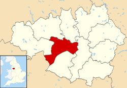
Salford ( SOL -fərd[ 5] Kota Salford , inggih punika silih tunggil borough métropolitan antuk status kota ring Manchester Raya , Inggris. Borough punika kawastanin antuk paumahan utama, Salford , nanging nglikupin wewidangan sané agengan ring sajeroning kota-kota Eccles , Swinton , Walkden lan Pendlebury .[ 6]
Albert, William (2007), The Turnpike Road System in England ISBN 978-0-521-03391-6 Bardsley, James Rodney (1960), The railways of Bolton, 1824–1959 Brownbill, John; Farrer, William (1911), A History of the County of Lancaster: Volume 5 , Victoria County History, ISBN 978-0-7129-1055-2 Clark, David M. (1973), Greater Manchester Votes: A Guide to the New Metropolitan Authorities , Redrose Curtis, Deborah (2007), Touching from a Distance: Ian Curtis and Joy Division ISBN 978-0-571-23956-6 Day, Lance; McNeil, Ian (1996), Biographical dictionary of the history of technology ISBN 978-0-415-06042-4 Cooper, Glynis (2005), Salford: An Illustrated History , The Breedon Books Publishing Company, ISBN 1-85983-455-8 Davey Smith, George; Dorling, Daniel; Shaw, Mary (2001), Poverty, inequality and health in Britain, 1800–2000 , Bristol: Policy Press, ISBN 978-1-86134-211-9 Davies, Andrew; Fielding, Steven (1992), Workers' Worlds: Cultures and Communities in Manchester and Salford, 1880–1939 , Manchester University Press, ISBN 978-0-7190-2543-3 Engels, Fredrich (1958) [1845], The Condition of the Working Class in England in 1844 ISBN 978-0-8047-0633-9 Frangopulo, N. J. (1977), Tradition in Action: The Historical Evolution of the Greater Manchester County , Wakefield: EP Publishing, ISBN 0-7158-1203-3 Frow, Edmund & Ruth (1984), Radical Salford: Episodes in Labour History , Radcliffe : Neil Richardson, ISBN 0-907511-49-X Gordon, Colin (1975), The Foundations of the University of Salford , Altrincham: John Sherratt and Son, ISBN 0-85427-045-0 Hampson, Charles P. (1972) [1930], Salford Through the Ages. The "Fons et Origo": of an Industrial City , Didsbury: E. J. Morten, ISBN 0-901598-66-6 Hayes, C. (2003), The Changing Face of Salford , Manchester: Acer Designs / Gosport: Ashford Colour Press Hopkins, Chris (2007), English Fiction in the 1930s: Language, Genre, History , Continuum International Publishing Group, ISBN 978-0-8264-8938-8 Huggins, Mike; Williams, Jack (2006), Sport and the English, 1918–1939 ISBN 0-415-33185-4 Johnson, Richard Hugh (1985), The Geomorphology of north-west England ISBN 0-7190-1745-9 Kenyon, Denise (1991), The Origins of Lancashire , Manchester University Press, ISBN 978-0-7190-3546-3 Little, Daran (2000), 40 Years of Coronation Street , ISBN 0-233-99806-3 Manchester Evening News Staff (2007), Salford past ISBN 978-1-84547-165-1 OCLC 145389850 McNeil, R.; Nevell, M (2000), A Guide to the Industrial Archaeology of Greater Manchester , Association for Industrial Archaeology, ISBN 0-9528930-3-7 Pevsner, Nikolaus (1969), Lancashire, The Industrial and Commercial South , London, England: Penguin Books, ISBN 0-14-071036-1 Pooley, Colin G.; Turnbull, Jean; Adams, Mags (2005), A mobile century?: changes in everyday mobility in Britain in the twentieth century ISBN 0-7546-4181-3 Purvis, June (2002), Emmeline Pankhurst ISBN 0-415-23978-8 Tomlinson, V. I. (1975), Tom Bergin; Dorothy N. Pearce; Stanley Shaw (eds.), Salford: a city and its past , City of Salford [Cultural Services Department] Tupling, G. H. (1952), The Turnpike Trusts of Lancashire , 94 , Manchester: Memoirs and Proceedings of the Manchester Literary and Philosophical Society, session 1952–1953 Vigeon, Evelyn V. (1975), Tom Bergin; Dorothy N. Pearce; Stanley Shaw (eds.), Salford: a city and its past , City of Salford [Cultural Services Department] Society for the Diffusion of Useful Knowledge (1841), Penny Cyclopaedia Charles Knight Walsh, Peter (2003), Gang War: The Inside Story of the Manchester Gangs , Milo Books, ISBN 978-1-903854-29-7
Wikimédia Commons madué média indik Salford
Wikivoyage madué panduan wisata Salford
Mal:Salford
Statutory City Region Distrik metropolitan Pemukiman utama Tukad Kanal Indik
Umum Perpustakaan nasional Lain-lain


