Tangub
Tangub | |
|---|---|
Ciudad | |
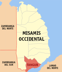
 Mapa de Misamis Occidental con Tangub resaltado | |
 | |
| Coordenadas: 8°4'0.0000"N, 123°45'0.0000"E | |
| Nación | Filipinas |
| Región | Mindanao del Norte (Región X) |
| Provincia | Misamis Occidental |
| Número de barangay | 55 |
| Gobierno | |
| • Type | ayuntamiento |
| • Electorado | Error en la secuencia de órdenes: la función «getValue» no existe. votantes (9 Mayo 2022) |
| Superficie | |
| • Total | 162,78 km2 (62,85 sq mi) |
| Elevation | 243 m (797 ft) |
| Populación (1 Mayo 2020) | |
| • Total | 68,389 |
| • Densidad | 0,42/km2 (1,1/sq mi) |
| • Hogares | 15,456 |
| Economía | |
| • Clase de ingresos | el ika cuatro clase de ciudad |
| • Incidencia de la pobreza | Error en la secuencia de órdenes: la función «getValue» no existe.% (Error: fecha y hora no válidas.)[2] |
| • Ingresos | ₱ <strong4a4df3e5">Error (Error: fecha y hora no válidas.) |
| • Activos | ₱ <strong4a4df3e5">Error (Error: fecha y hora no válidas.) |
| • Pasivos | ₱ <strong4a4df3e5">Error (Error: fecha y hora no válidas.) |
| • Gastos | ₱ <strong4a4df3e5">Error (Error: fecha y hora no válidas.) |
| Huso horario | UTC+8 (PST) |
| Código postal | 7214 |
| PSGC | |
| Código telefonico | 88 |
| Lenguaje nativo | Subanon Cebuano Tagalog |
| Website | http://tangubcity.gov.ph/ |
Tangub el ika cuatro clase de ciudad na provincia de Misamis Occidental, Filipinas. Tiene este zona de 162.78 kilometro cuadrado.
Comporme del 1 Mayo 2020 censo este tiene papulidad de 68,389 personas y 15,456 hogares. El designada codigo postal 7214 y PSGC 104215000.
Barangay
[revisa | revisa codigo]
|
|
|
Demografía
[revisa | revisa codigo]| Año | Populación | ±% p.a. |
|---|---|---|
| 1939 | 44 743 | — |
| 1948 | 20 353 | −8.38% |
| 1960 | 21 101 | +0.30% |
| 1970 | 30 918 | +3.89% |
| 1975 | 40 461 | +5.54% |
| 1980 | 40 401 | −0.03% |
| 1990 | 42 926 | +0.61% |
| 1995 | 46 004 | +1.31% |
| 2000 | 49 695 | +1.67% |
| 2007 | 56 644 | +1.82% |
| 2010 | 59 892 | +2.05% |
| 2015 | 63 011 | +0.97% |
| 2020 | 68 389 | +1.62% |
| Ref: Autoridad de Estadísticas de Filipinas[3][4][5][6] | ||
Referencias
[revisa | revisa codigo]- ↑ «Province: Misamis Occidental». PSGC Interactive. Quezon City, Philippines: Philippine Statistics Authority. Consultado el Diciembre 17, 2016.
- ↑ «PSA Releases the 2021 City and Municipal Level Poverty Estimates» (2 Abril 2024).
- ↑ Census of Population (2015). "Region X (Northern Mindanao)". Total Population by Province, City, Municipality and Barangay. Philippine Statistics Authority.
- ↑ Census of Population and Housing (2010). "Region X (Northern Mindanao)". Total Population by Province, City, Municipality and Barangay. NSO.
- ↑ Censuses of Population (1903–2007). "Region X (Northern Mindanao)". Table 1. Population Enumerated in Various Censuses by Province/Highly Urbanized City: 1903 to 2007. NSO.
- ↑ «Province of Misamis Occidental». Municipality Population Data. Local Water Utilities Administration Research Division. Consultado el Diciembre 17, 2016.
Enlaces externos
[revisa | revisa codigo]- PhilAtlas.com
- Philippine Standard Geographic Code
- Local Governance Performance Management System
- tangubcity
.gov .ph
| Oroquieta (cabecera) | |
| Municipalidad: | Aloran ▪ Baliangao ▪ Bonifacio ▪ Calamba ▪ Clarin ▪ Concepcion ▪ Don Victoriano Chiongbian ▪ Jimenez ▪ Lopez Jaena ▪ Panaon ▪ Plaridel ▪ Sapang Dalaga ▪ Sinacaban ▪ Tudela |
| Ciudad: | Oroquieta ▪ Ozamiz ▪ Tangub |