Saint-Maurice-Thizouaille
| Saint-Maurice-Thizouaille | ||
|---|---|---|

|
||
| Staat | ||
| Region | Bourgogne-Franche-Comté | |
| Département (Nr.) | Yonne (89) | |
| Arrondissement | Auxerre | |
| Kanton | Charny Orée de Puisaye | |
| Gemeindeverband | L’Aillantais en Bourgogne | |
| Koordinaten | 47° 50′ N, 3° 22′ O | |
| Höhe | 123–195 m | |
| Fläche | 1,95 km² | |
| Einwohner | 255 (1. Januar 2022) | |
| Bevölkerungsdichte | 131 Einw./km² | |
| Postleitzahl | 89110 | |
| INSEE-Code | 89361 | |
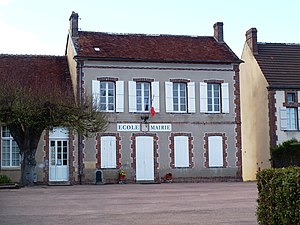
 Bürgermeisteramt (Mairie) und Schulgebäude | ||
Saint-Maurice-Thizouaille ist eine französische Gemeinde mit 255 Einwohnern (Stand 1. Januar 2022) im Département Yonne in der Region Bourgogne-Franche-Comté; sie gehört zum Arrondissement Auxerre und zum Kanton Charny Orée de Puisaye. Der Ort liegt am Ufer des Flusses Tholon.
Geografie
[Bearbeiten | Quelltext bearbeiten]Saint-Maurice-Thizouaille liegt westlich des Zentrums des Départements Yonne ca. 15 Kilometer nordwestlich von Auxerre.
Umgeben wird Saint-Maurice-Thizouaille von den vier Nachbargemeinden:
| Chassy | ||
| Le Val d’Ocre | 
|
Poilly-sur-Tholon |
| Saint-Maurice-le-Vieil |
Bevölkerungsentwicklung
[Bearbeiten | Quelltext bearbeiten]| Saint-Maurice-Thizouaille: Einwohnerzahlen von 1793 bis 2016 | ||||
|---|---|---|---|---|
| Jahr | Einwohner | |||
| 1793 | 227 | |||
| 1800 | 236 | |||
| 1806 | 256 | |||
| 1821 | 262 | |||
| 1831 | 289 | |||
| 1836 | 313 | |||
| 1841 | 291 | |||
| 1846 | 286 | |||
| 1851 | 319 | |||
| 1856 | 306 | |||
| 1861 | 327 | |||
| 1866 | 339 | |||
| 1872 | 363 | |||
| 1876 | 359 | |||
| 1881 | 354 | |||
| 1886 | 350 | |||
| 1891 | 354 | |||
| 1896 | 310 | |||
| 1901 | 297 | |||
| 1906 | 275 | |||
| 1911 | 257 | |||
| 1921 | 232 | |||
| 1926 | 221 | |||
| 1931 | 211 | |||
| 1936 | 193 | |||
| 1946 | 209 | |||
| 1954 | 207 | |||
| 1962 | 196 | |||
| 1968 | 148 | |||
| 1975 | 151 | |||
| 1982 | 180 | |||
| 1990 | 170 | |||
| 1999 | 210 | |||
| 2006 | 262 | |||
| 2011 | 250 | |||
| 2016 | 268 | |||
| Quelle(n): EHESS/Cassini bis 1999,[1] INSEE ab 2006[2] Anmerkung(en): Ab 1962 offizielle Zahlen ohne Einwohner mit Zweitwohnsitz | ||||
Sehenswürdigkeiten
[Bearbeiten | Quelltext bearbeiten]- Schloss Saint-Maurice-Thizouaille aus dem 14. Jahrhundert, seit 1981 teilweise als Monument historique eingeschrieben
- Kirche Saint-Maurice
-
Schloss Saint-Maurice-Thizouaille
-
Kirche Saint-Maurice
Persönlichkeiten
[Bearbeiten | Quelltext bearbeiten]- Tristan de Salazar, Erzbischof von Sens, * um 1431 in Saint-Maurice-Thizouaille
Einzelnachweise
[Bearbeiten | Quelltext bearbeiten]- ↑ Notice Communale Saint-Maurice-Thizouaille. EHESS, abgerufen am 25. Januar 2023 (französisch).
- ↑ Populations légales 2016 Commune de Saint-Maurice-Thizouaille (89361). INSEE, abgerufen am 25. Januar 2023 (französisch).
Weblinks
[Bearbeiten | Quelltext bearbeiten]Commons: Saint-Maurice-Thizouaille – Sammlung von Bildern


