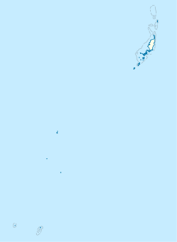
Peleliu
| Peleliu | ||
|---|---|---|
 | ||
 Flago | ||
| state of Palau [+] | ||
| Akvejo | Pacifiko | |
| Koordinatoj | 7° 1′ N, 134° 15′ O (mapo)7.0125134.25027777778Koordinatoj: 7° 1′ N, 134° 15′ O (mapo) | |
| Akvokolektejo | 13 km² (1 300 ha) [+] | |
| Areo | 13 km² (1 300 ha) [+] | |
| Horzono | UTC+09:00 [+] | |
 |
||
| Peleliu | ||
Peleliu (aŭ Beliliou) estas insulo en la insulando Palaŭo. Peleliu formas, kun du malgrandaj insuloj nordoriente, unu el dek ses subŝtatoj de Palaŭo. La insulo famis kiel loko de la Batalo de Peleliu en la Dua Mondmilito.
Peleliu estas proksimume 10 kilometrojn nordoriente de la insulo Angaur kaj 40 kilometrojn sudokcidente de la insulo Koror. Peleliu havas totalan areon de 13 km². Je 2000, estis ĉirkaŭ 571, kio faras ĝin la tria plej loĝata subŝtato de Palaŭo.[1] Plej el la loĝantaro de la insulo loĝas en la vilaĝo Kloulklubed kiu estas la subŝtata ĉefurbo en la nordokcidenta marbordo.
7° 0′ N 134° 15′ O / 7.000 °N, 134.250 °O (mapo)
Notoj
[redakti | redakti fonton]- ↑ Patterson, Carolyn Bennett, et al. "At the Birth of Nations: In the Far Pacific." gazeto National Geographic, Oktobro 1986 paĝo 493. National Geographic Virtual Library, Alirita la 16an de Decembro 2018. "An example is Peleliu, the tragic island where more than 13,000 Americans and Japanese died during less than three months of fighting, often hand to hand, in the autumn of 1944. Pat and I went to Peleliu from Koror, the republic's capital, by speedboat, a wave-tossing, rear-slapping 45 minutes, and arrived to discover it was election day, with five candidates running for governor. Although Peleliu claims a population of 2,000 people, only 400 actually live there. More registered voters live in Koror than on their home island, and 800 send votes from Guam. The situation is similar in Palau's other states."


