زایدپلاس
زایدپلاس | |
|---|---|
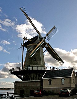
 Wind mill "Windlust" in Nieuwerkerk aan den IJssel | |
 موقعیت زایدپلاس در نقشه | |
| مختصات: ۵۱°۵۸′ شمالی ۴°۳۷′ شرقی / ۵۱٫۹۶۷°شمالی ۴٫۶۱۷°شرقی | |
| کشور | هلند |
| استان | هلند جنوبی |
| تأسیسشده | ۱ ژانویه ۲۰۱۰ |
| حکومت | |
| • نهاد | Municipal council |
| • Mayor | Gert-Jan Kats (SGP) |
| مساحت | |
| • کل | ۶۴٫۰۵ کیلومتر مربع (۲۴٫۷۳ مایل مربع) |
| • خشکی | ۵۸٫۰۲ کیلومتر مربع (۲۲٫۴۰ مایل مربع) |
| • آب | ۶٫۰۳ کیلومتر مربع (۲٫۳۳ مایل مربع) |
| ارتفاع | −۶ متر (−۲۰ فوت) |
| کمترین ارتفاع | −۶٫۷۶ متر (−۲۲٫۱۸ فوت) |
| جمعیت (ژانویه 2019)[۵] | |
| • کل | ۴۲٬۷۶۲ |
| • تراکم | ۷۳۷/کیلومتر مربع (۱۹۱۰/مایل مربع) |
| منطقهٔ زمانی | یوتیسی +۱ (زمان) |
| • تابستانی (DST) | یوتیسی +۲ (ساعت تابستانی اروپای مرکزی) |
| Postcode | ۲۷۵۰–۲۷۶۱, ۲۸۴۰–۲۸۴۱, ۲۹۱۰–۲۹۱۴ |
| Area code | ۰۱۸۰, ۰۱۸۲, ۰۷۹ |
| وبگاه | www |
زایدپلاس (به هلندی: Zuidplas) یک شهرستان در هلند است که در هلند جنوبی واقع شدهاست.[۶] زایدپلاس −۶ متر بالاتر از سطح دریا واقع شدهاست.
جستارهای وابسته
[ویرایش]منابع
[ویرایش]- ↑ "College van B&W" [Board of mayor and aldermen] (به هلندی). Gemeente Zuidplas. Archived from the original on 13 August 2013. Retrieved 31 August 2013.
- ↑ "Kerncijfers wijken en buurten 2020" [Key figures for neighbourhoods 2020]. StatLine (به هلندی). CBS. 24 July 2020. Retrieved 19 September 2020.
- ↑ "Postcodetool for 2914KM". Actueel Hoogtebestand Nederland (به هلندی). Het Waterschapshuis. Archived from the original on 26 December 2018. Retrieved 31 August 2013.
- ↑ "Laagste punt van Nederland" [Lowest point of the Netherlands] (به هلندی). Gemeente Zuidplas. Archived from the original on 12 September 2013. Retrieved 31 August 2013.
- ↑ "Bevolkingsontwikkeling; regio per maand" [Population growth; regions per month]. CBS Statline (به هلندی). CBS. 1 January 2019. Retrieved 1 January 2019.
- ↑ مشارکت کنندگان ویکیپدیای انگلیسی. «Zuidplas».
پیوند به بیرون
[ویرایش]در ویکیانبار پروندههایی دربارهٔ زایدپلاس موجود است.

