Biddenden
| Biddenden | |||

| |||
| Administration | |||
|---|---|---|---|
| Pays | |||
| Nation | |||
| Comté | Kent | ||
| District | Ashford | ||
| Force de police | Kent | ||
| Incendie | Kent | ||
| Ambulance | South East Coast | ||
| Code postal | TN27 | ||
| Indicatif | 01580 | ||
| Démographie | |||
| Population | 2 574 hab. (2011) | ||
| Densité | 88 hab./km2 | ||
| Géographie | |||
| Coordonnées | 51° 06′ 50″ nord, 0° 38′ 39″ est | ||
| Superficie | 2 912 ha = 29,12 km2 | ||
| Localisation | |||
| Géolocalisation sur la carte : Royaume-Uni
Géolocalisation sur la carte : Royaume-Uni
| |||
| modifier |
|||
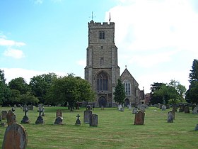
Biddenden est un village et une paroisse civile situé dans le borough d'Ashford dans le comté du Kent. En 2011, sa population était de 2 574 habitants.
Notes et références
[modifier | modifier le code]- (en) Cet article est partiellement ou en totalité issu de l’article de Wikipédia en anglais intitulé « Biddenden » (voir la liste des auteurs).

