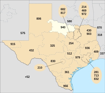
Indicatif régional 940

L'indicatif régional 940 est l'un des multiples indicatifs téléphoniques régionaux de l'État du Texas aux États-Unis.
Cet indicatif dessert les régions de Wichita Falls et de Denton.
La carte ci-contre indique en blanc le territoire couvert par l'indicatif 940.
L'indicatif régional 940 fait partie du plan de numérotation nord-américain.
Comtés desservis par l'indicatif
[modifier | modifier le code]Archer, Baylor, Childress, Clay, Cooke, Cottle, Denton, Foard, Grayson, Hardeman, Haskell, Jack, Knox, Montague, Palo Pinto, Parker, Stonewall, Throckmorton, Wichita, Wilbarger, Wise et Young
Villes desservies par l'indicatif
[modifier | modifier le code]Alvord, Archer City, Argyle, Aubrey, Bellevue, Benjamin, Bluegrove, Bowie, Boyd, Bridgeport, Bryson, Burkburnett, Byers, Cee Vee, Chico, Childress, Chillicothe, Corinth, Crowell, Decatur, Dennis, Denton, Electra, Era, Forestburg, Gainesville, Gordon, Goree, Graford, Graham, Greenwood, Harrold, Haskell, Henrietta, Holliday, Iowa Park, Jacksboro, Jermyn, Justin, Kamay, Knox City, Krum, Lantana, Lake Dallas, Lindsay, Loving, Megargel, Millsap, Mineral Wells, Mingus, Montague, Muenster, Munday, Myra, Newark, Newcastle, Nocona, O'Brien, Oklaunion, Old Glory, Olney, Palo Pinto, Paradise, Perrin, Petrolia, Pilot Point, Ponder, Poolville, Quanah, Ringgold, Rochester, Rosston, Rule, Saint Jo, Sanger, Santo, Scotland, Seymour, Sheppard Air Force Base, Slidell, South Bend, Sunset, Tell, Throckmorton, Tioga, Valley View, Vernon, Weinert, Whitt, Wichita Falls, Windthorst et Woodson