ハドリー山
| ハドリー山 | |
|---|---|
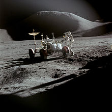
 アポロ15号が月面着陸した際に撮影されたハドリー山の写真。手前に見えるのは月面車と宇宙飛行士ジェームズ・アーウィン。 | |
| 標高 | 約4600 m |
| 所在地 | 月 |
| 位置 | 北緯26度30分 東経4度42分 / 北緯26.5度 東経4.7度 |
| 山系 | アペニン山脈 |
| 初登頂 | 記録なし |
ハドリー山(Mons Hadley)は、月のアペニン山脈北部にある山塊。山頂地点の月面座標は北緯26.5度、東経4.7度であり、雨の海の南東縁に位置する。高さは4.6キロメートルで、裾野の最大直径は25キロメートルである。
ハドリー山の南西には、1971年にアポロ15号が着陸した腐敗の沼がある。腐敗の沼のさらに南西には、ハドリー・デルタ山と呼ばれる高さ3.5キロメートルの峰がある。ハドリー・デルタ山は北緯25.8度、東経3.8度に位置する。ハドリー山およびハドリー・デルタ山の西方には、ハドリー溝と呼ばれる曲がりくねった深い裂溝が走っている。
ハドリー山やハドリー・デルタ山、ハドリー溝など、これらの地名は、18世紀のイングランドの天文学者ジョン・ハドリーにちなんで名づけられた。
参考文献
[編集]- Andersson, L. E.; Whitaker, E. A., (1982). NASA Catalogue of Lunar Nomenclature. NASA RP-1097
- Blue, Jennifer (July 25, 2007). “Gazetteer of Planetary Nomenclature”. USGS. 2007年8月5日閲覧。
- Bussey, B.; Spudis, P. (2004). The Clementine Atlas of the Moon. New York: Cambridge University Press. ISBN 0-521-81528-2
- Cocks, Elijah E.; Cocks, Josiah C. (1995). Who's Who on the Moon: A Biographical Dictionary of Lunar Nomenclature. Tudor Publishers. ISBN 0-936389-27-3
- McDowell, Jonathan (July 15, 2007). “Lunar Nomenclature”. Jonathan's Space Report. 2007年10月24日閲覧。
- Menzel, D. H.; Minnaert, M.; Levin, B.; Dollfus, A.; Bell, B. (1971). “Report on Lunar Nomenclature by The Working Group of Commission 17 of the IAU”. Space Science Reviews 12: 136.
- Moore, Patrick (2001). On the Moon. Sterling Publishing Co.. ISBN 0-304-35469-4
- Price, Fred W. (1988). The Moon Observer's Handbook. Cambridge University Press. ISBN 0521335000
- Rükl, Antonín (1990). Atlas of the Moon. Kalmbach Books. ISBN 0-913135-17-8
- Webb, Rev. T. W. (1962). Celestial Objects for Common Telescopes (6th revision ed.). Dover. ISBN 0-486-20917-2
- Whitaker, Ewen A. (1999). Mapping and Naming the Moon. Cambridge University Press. ISBN 0-521-62248-4
- Wlasuk, Peter T. (2000). Observing the Moon. Springer. ISBN 1852331933
外部リンク
[編集]- LTO-41B4 Hadley — L&PI ハドリー山付近の正射地形図
