국도 제30호선 (미국)
| 미국의 일반 국도 | |
|---|---|
| 미국 국도 제30호선 | |
| 노선도 | |
 | |
| 총연장 | 3,073 mi (4,946 km)[1]
|
| 개통년 | 1926년[1] ~ 현재
|
| 기점 | |
| 종점 | |
| 주요 교차도로 |
|
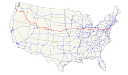
미국 국도 제30호선(U.S. Route 30)은 미국 국토의 동서를 잇는 국도이다. 총연장은 3073 마일로 미국에서 6호선, 20호선에 이어 3번째로 긴 국도이다.
서쪽의 오리건주 애스토리아에서 시작되어 동쪽의 뉴저지주 애틀랜틱시티에 이른다.
샌프란시스코-뉴욕을 잇는 미국 최초의 대륙 횡단 고속도로인 링컨 하이웨이(Lincoln Highway)의 대부분의 구간이 30호선에 속해 있다.
주별 구간
[편집]
| 마일(mi) | 킬로미터(km) | |
|---|---|---|
| 오리건 | 477.47[2] | 768.41 |
| 아이다호 | 415.55[3] | 668.77 |
| 와이오밍 | 454.37[4] | 731.24 |
| 네브래스카 | 451[5] | 726 |
| 아이오와 | 330.43[6] | 531.77 |
| 일리노이 | 151.32[7] | 243.53 |
| 인디애나 | 151.8[8] | 244.3 |
| 오하이오 | 245.39[9] | 394.92 |
| 버지니아 | 4[10] | 6 |
| 펜실베이니아 | 324[11] | 521 |
| 뉴저지 | 58.26[12] | 93.76 |
| 합계 | 3064 | 4930 |
같이 보기
[편집]각주
[편집]- ↑ 가 나 Droz, Robert V. U.S. Highways : From US 1 to (US 830) Archived 2006년 2월 15일 - 웨이백 머신. URL accessed 02:55, 17 April 2006 (UTC).
- ↑ Oregon Department of Transportation, TransGIS{{ 보관됨 2006-06-02 - 미국 의회도서관 웹 아카이브 and Equations and Milepoint Range Information Archived 2007년 3월 11일 - 웨이백 머신, accessed January 30, 2006
- ↑ Idaho Transportation Department, May 4, 2004 Milepost Log - State Highway System Archived 2006년 3월 22일 - 웨이백 머신
- ↑ Wyoming Department of Transportation, November 2004 Reference Marker Book Archived 2007년 3월 11일 - 웨이백 머신
- ↑ “Nebraska Roads: US 30”. 2014년 10월 9일에 확인함.
- ↑ Iowa Department of Transportation, 2004 Geographic Information Systems Statewide and County Data Archived 2007년 8월 17일 - 웨이백 머신
- ↑ Illinois Department of Transportation, 2004 GIS Data Archived 2007년 8월 10일 - 웨이백 머신
- ↑ “Indiana Highway Ends - US 30”. 2012년 10월 8일에 원본 문서에서 보존된 문서. 2014년 10월 9일에 확인함.
- ↑ Ohio Department of Transportation, January 1, 2005 Straight Line Diagrams Archived 2003년 2월 19일 - 웨이백 머신
- ↑ Approximated from Mapquest
- ↑ “Pennsylvania Highways: US 30”. 2014년 10월 9일에 확인함.
- ↑ New Jersey Department of Transportation, 2005 Straight Line Diagrams - US 30 (PDF)
외부 링크
[편집] 위키미디어 공용에 국도 제30호선 관련 미디어 분류가 있습니다.
| 이 글은 도로에 관한 토막글입니다. 여러분의 지식으로 알차게 문서를 완성해 갑시다. |

