Simão Dias
| Gemeente in Brazilië | |||
|---|---|---|---|
| Situering | |||
| Regio | Noordoost | ||
| Staat | Sergipe | ||
| Mesoregio | Agreste Sergipano | ||
| Microregio | Lagarto | ||
| Coördinaten | 10° 44′ ZB, 37° 49′ WL | ||
| Algemeen | |||
| Oppervlakte | 560,8 km² | ||
| Inwoners (2009) |
44.387 (87,29 inw./km²) | ||
| Hoogte | 263 m | ||
| Politiek | |||
| Burgemeester | Denisson Déda | ||
| Gesticht | 1890 | ||
| Overig | |||
| Tijdzone | UTC−3 | ||
| HDI | 0,591 | ||
| Website | simaodias.se.gov.br | ||
| Detailkaart | |||

| |||
| Locatie van Simão Dias in de staat Sergipe | |||
| Foto's | |||

| |||
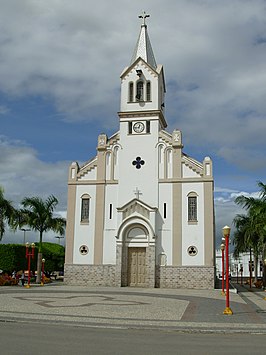
| Katholieke kerk Senhora Sant'Anna in Simão Dias | |||
| |||
Simão Dias is een gemeente in de Braziliaanse deelstaat Sergipe. De gemeente telt 44.387 inwoners (schatting 2009).
Aangrenzende gemeenten
[bewerken | brontekst bewerken]De gemeente grenst aan Poço Verde, Tobias Barreto, Riachão do Dantas, Lagarto, Pedra Mole, Pinhão en Paripiranga (BA).
Geboren
[bewerken | brontekst bewerken]- Belivaldo Chagas (1960), gouverneur van Sergipe[1]
Externe link
[bewerken | brontekst bewerken]Zie de categorie Simão Dias van Wikimedia Commons voor mediabestanden over dit onderwerp.
Bronnen, noten en/of referenties
- ↑ Gouverneurschap in de periode 2018-2023


