Mahlsdorf
Mahlsdorf | |
|---|---|
Quairter o Berlin | |
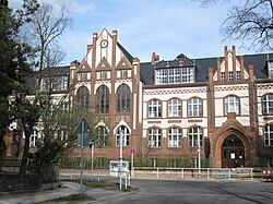
 Friedrich Schiller elementar schuil | |
| Coordinates: 52°30′22″N 13°36′54″E / 52.50611°N 13.61500°ECoordinates: 52°30′22″N 13°36′54″E / 52.50611°N 13.61500°E | |
| Kintra | Germany |
| State | Berlin |
| City | Berlin |
| Borough | Marzahn-Hellersdorf |
| Foondit | 1753 |
| Area | |
| • Total | 12.9 km2 (5.0 sq mi) |
| Population (2009-12-31) | |
| • Total | 26,852 |
| • Density | 2,100/km2 (5,400/sq mi) |
| Time zone | CET/CEST (UTC+1/+2) |
| Postal codes | (nr. 1004) 12623 |
| Vehicle registration | B |

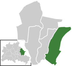
Mahlsdorf is a locality (Ortsteil) athin the Berlin burgh (Bezirk) o Marzahn-Hellersdorf. Till 2001 it wis pairt o the umwhile burgh o Hellersdorf.
History
[eedit | eedit soorce]The locality wis mentioned for the first time in a document o 1345, namit as Malterstorp. Till 1920 it wis a municipality o the umwhile Niederbarnim destrict, mergit intae Berlin wi the "Greater Berlin Act".[1]
Geografie
[eedit | eedit soorce]Owerview
[eedit | eedit soorce]Mahlsdorf is locatit in the eastren suburb o Berlin, at the borders wi the Brandenburger destrict o Märkisch-Oderland. It is boondit bi the municipality o Neuenhagen an Hoppegarten, wi its hamlets Hönow, Waldesruh an Birkenstein. The Berliner borderin localities are Hellersdorf, Kaulsdorf an Köpenick (in Treptow-Köpenick destrict). In the sooth o the quairter thare are the lakes Eisensee an pairt o the Habermannsee, dividit wi Kaulsdorf.
Subdivision
[eedit | eedit soorce]Mahlsdorf is dividit intae 2 zones (Ortslagen):
Transport
[eedit | eedit soorce]The locality, crossed bi the federal heich-gates B1 an B5, is servit bi the S-Bahn line S5, at the rail station o Mahlsdorf. Birkenstein station, situatit in the homonymous hamlet o the toun o Hoppegarten, is close tae the eastren suburb o the quairter.
Photogallery
[eedit | eedit soorce]-
The Gründerzeitmuseum
-
The hill Berliner Balkon
-
Railwey station
References
[eedit | eedit soorce]- ↑ (in German) Historical infos about Mahlsdorf Archived 2009-07-04 at the Wayback Machine
Leeteratur
[eedit | eedit soorce]- Kurt Pomplun: "Berlins alte Dorfkirchen" (page 59). Verlag Bruno Hessling, Berlin 1967
Freemit airtins
[eedit | eedit soorce]![]() Media relatit tae Mahlsdorf at Wikimedia Commons
Media relatit tae Mahlsdorf at Wikimedia Commons
- (in German) Mahlsdorf offeecial wabsteid Archived 2013-02-08 at the Wayback Machine


