Lake Sebu
| Lake Sebu | |
|---|---|
 | |
| Location | South Cotabato, Mindanao |
| Coordinates | 6°13′45″N 124°42′21″E / 6.22917°N 124.70583°E |
| Native name | Lanaw Sbù (Tboli) |
| Basin countries | Philippines |
| Surface area | 354 ha (3.54 km2) |
| Max. depth | 34 m (111.55 ft) |
| Surface elevation | 1,000 m (3,280.84 ft) |
| Islands | 11 islets/islands |
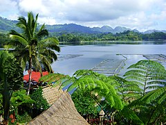
Lake Sebu (Tboli language|Tboli: Lanaw Sbù,[1] /sbuʔ/; Hiligaynon: Linaw sg Sëbu, /səˈbuʔ/; Filipino: Lawa ng Sëbu) is a natural lake located in the Philippine municipality of Lake Sebu of South Cotabato.[2] The Philippine government has recognized it as one of the country's most important watersheds.[3] Lake Sebu is one of the many bodies of water supplying important irrigation to the provinces of Sultan Kudarat and South Cotabato.
Ancestral domain
[change | change source]The villages around the lake were unified into an independent municipality, also named Lake Sebu, and was declared a protected area in entirety. The Philippine Department of Environment and Natural Resources officially issued a Department Administrative Order (DAO) as such, that the lake and its surrounding land are the domain of the indigenous Tboli and Ubo tribes of Surallah, the traditional dwellers of Lake Sebu.[4]
Gallery
[change | change source]-
Lake Sebu, as seen from Punta Isla
-
The lake is one of the most important watershed areas in the Philippines
-
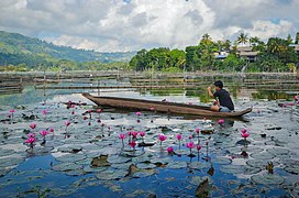
Traditional dugout canoes, called owong, in Lake Sebu
-
Indigenous people thriving near Lake Sebu
References
[change | change source]- ↑ "Tboli Dictionary » Search Results » sbu". Archived from the original on 2020-12-01. Retrieved 2025-01-15.
- ↑ Bagnol, Raquel C. (August 9, 2004). "Postscripts from Lake Sebu". Sunstar. Retrieved October 10, 2008.
- ↑ Estabillo, Allen V. (September 26, 2008). "SouthCot moves to save Lake Sebu". MindaNews. Archived from the original on April 13, 2010. Retrieved October 10, 2008.
- ↑ Logong, Datu Ontog. "Experiences and Challenges of the Indigenous People in Co-managing Forest Resources: The Lake Sebu Ancestral Domain Community Association". FAO. Retrieved October 10, 2008.


