Mont Mézenc
| Mont Mézenc | |
|---|---|
 The two summits of Mont Mézenc : the northern summit to the left and the southern summit to the right. | |
| Highest point | |
| Elevation | 1,753 m (5,751 ft)[1] |
| Prominence | 793 m (2,602 ft)[1] |
| Coordinates | 44°54′40″N 4°11′27″E / 44.91111°N 4.19083°E |
| Geography | |
 Mont Mézenc France | |
| Location | Ardèche and Haute-Loire departments, France |
| Parent range | Massif Central |
| Climbing | |
| Easiest route | from Les Estables |
Mont Mézenc is a French mountain in the Massif du Mézenc, part of the Massif Central in the Auvergne-Rhône-Alpes region. It is on the border of the Ardèche and Haute-Loire departments and is the highest mountain of both departments.
The mountain is in the "Natural regional park of the Mountains of Ardèche" (French: Parc naturel régional des Monts d'Ardèche).
Geography
[change | change source]Mont Mézenc is the highest mountain of the eastern border of the Massif Central.[2] It is formed by two summits that are separated for a distance of about 0.5 km (0.3 mi):
- The southern summit is the highest with an altitude of 1,753 m (5,751 ft); it is in the commune of Borée, Ardèche department, and is the highest point in this department.
- The northern summit has an altitude of 1,744 m (5,722 ft), where the communes La Rochette (Ardèche), Chaudeyrolles (Haute-Loire) and Les Estables (Haute-Loire) meet. It is the highest point of the Haute-Loire department. There is an iron cross on top of this summit; it was put there by French prisoners when they returned from Germany.
The Mont Mézenc has a volcanic origin; it is a dome of phonolite, a kind volcanic rock.[3] The mountain is covered by grasslands and heaths.
-
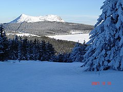 Mont Mézenc in winter.
 -
 Massif du Mézenc in the Massif Central.
 -
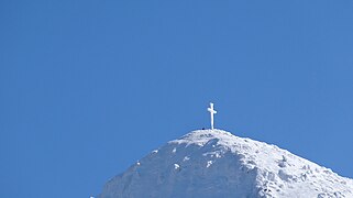 The cross on the summit.


References
[change | change source]- ↑ 1.0 1.1 "Mont Mézenc, France". Peakbagger.com. Retrieved 29 September 2017.
- ↑ "Mont Mézenc (1753m)" (in French). altituderando. Retrieved 29 September 2017.
- ↑ "Le Mézenc - Mézenc et Gerbier, vacances randonnées sur le Chemin de Stevenson (GR70) : Mézenc Loire Sauvage". Mezencloiresauvage.com. Archived from the original on 21 July 2017. Retrieved 29 September 2017.
Other websites
[change | change source]Wikimedia Commons has media related to Mont Mézenc.
- Un matin sur le mont chauve des Cévennes (in French)