ساوتھ ایسٹ (واشنگٹن، ڈی سی)
| ساوتھ ایسٹ (واشنگٹن، ڈی سی) Southeast | |
|---|---|
| Quadrant of Washington, D.C. | |
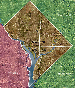
 Color-enhanced یونائیٹڈ اسٹیٹ جیولوجیکل سروے satellite image of Washington, D.C.، taken اپریل 26, 2002. The "crosshairs" in the image mark the quadrant divisions of Washington, with the ریاستہائے متحدہ کیپٹل at the center of the dividing lines. To the west of the Capitol extends the نیشنل مال، visible as a thin green band in the image. The Northwest quadrant is the largest, located north of the Mall and west of North Capitol Street. | |
| خود مختار ریاستوں کی فہرست | |
| ضلع | |
ساوتھ ایسٹ (لاطینی: Southeast) ریاست ہائے متحدہ کا ایک آباد مقام جو واشنگٹن، ڈی سی میں واقع ہے۔ [1]
مزید دیکھیے
[ترمیم]حوالہ جات
[ترمیم]- ↑ انگریزی ویکیپیڈیا کے مشارکین۔ "Southeast (Washington, D.C.)"
|
|