-
 两石山得名于此岩塔
 -
 “仙宫”:图中石堆和三角柱所在的土堆是一个墓道
 -
 Ballyedmonduff楔形墓穴
 -
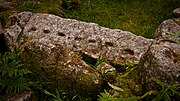 Ballyedmonduff楔形墓穴的壁画
 -
 东坡上的巨石
两石山 (爱尔兰)
| 两石山 (Binn Dá Charraig) | |
|---|---|
 从南部眺望两石山 | |
| 别名 | 黑山;[1] 斯莱夫 莱加[2] |
| 最高点 | |
| 海拔 | 536米(1,759英尺)[3] |
| 地形突起度 | 171米(561英尺)[2] |
| 坐标 | 53°14′10″N 6°14′30″W / 53.236194°N 6.241557°W [3] |
| 地理 | |
 两石山 大都柏林  两石山 两石山 (愛爾蘭島) | |
| 位置 | 爱尔兰邓莱里 |
| 所属山脉 | 都柏林山脉 |
两石山[4],是位于爱尔兰的一座山。536米(1759英尺) 高[3],是爱尔兰第382高山[2]。它是都柏林山脉的最高点,这座山名字来源于位于山顶东南部的两座花岗岩塔[5]。从被称为仙女城堡的山顶上,可以看到都柏林中塔拉,霍斯绝大部分景色[3]。山顶大部分是浅沼泽,而蕨类植物和金雀花覆盖着山脚[6]。这座山也是红松鸡的重要栖息地[7]。
景象
[编辑]两石山


引用
[编辑]注释
[编辑]- ^ The Dublin & North Wicklow Mountains (地图). 1:30,000. EastWest Mapping. 2009. ISBN 978-1-899815-23-4.
- ^ 2.0 2.1 2.2 Two Rock Mountain. Mountain Views. [2010-07-25]. (原始内容存档于2012-09-06).
- ^ 3.0 3.1 3.2 3.3 Ordnance Survey Ireland, Discovery Series No. 50
- ^ Two Rock Mountain. Placenames Database of Ireland. Department of Culture, Heritage and the Gaeltacht. [5 June 2020]. (原始内容存档于2013-12-14).
- ^ Joyce, p. 134.
- ^ Pearson, p. 305.
- ^ CAAS (Environmental Services). Section 3 Dún Laoghaire–Rathdown's Baseline Environment (PDF). Environmental Report of the Draft Dún Laoghaire-Rathdown County Development Plan 2010-2016 Strategic Environmental Assessment (pdf). Dublin: Dún Laoghaire–Rathdown County Council. February 2009: 11 [2010-07-27]. (原始内容存档于2011-09-27).
参考书目
[编辑]- Corlett, Christiaan. Antiquities of Old Rathdown. The archaeology of south County Dublin and north County Wicklow. Bray, County Wicklow: Wordwell. 1999. ISBN 1-869857-29-1.
- Fourwinds, Tom. Monu-mental About: Prehistoric Dublin. Dublin: Nonsuch Publishing Limited. 2006. ISBN 978-1-84588-560-1.
- Healy, Patrick. Rathfarnham Roads (pdf). Dublin: South Dublin Libraries. April 2005 [2010-08-07]. ISBN 0-9547660-3-2. (原始内容存档 (PDF)于2023-08-08).
- Herity, Michael (编). Ordnance Survey Letters Dublin. Dublin: Four Masters Press. 2001. ISBN 1-903538-05-X.
- Joyce, Weston St. John. The Neighbourhood of Dublin. Dublin: Hughes and Hughes. 1994 [first published 1912]. ISBN 0-7089-9999-9.
- Discovery Series No. 50: Dublin, Kildare, Meath, Wicklow (地图) 6th. 1:50,000. Discovery Series. Ordnance Survey Ireland. 2010. ISBN 978-1-907122-17-0.
- Pearson, Peter. Between the Mountains and the Sea. Dun Laoghaire–Rathdown County. Dublin: O'Brien Press. 1998. ISBN 0-86278-582-0.