Wiki Article
Ravangla
Nguồn dữ liệu từ Wikipedia, hiển thị bởi DefZone.Net
Ravangla
Rabong | |
|---|---|
 Ravangla, Namchi District, 737139 | |
 Ravangla Location in Sikkim, India  Ravangla Ravangla (India) | |
| Coordinates: 27°17′33″N 88°21′34″E / 27.29250°N 88.35944°E | |
| Country | |
| State | |
| District | Namchi |
| Population (2020)[1] | |
• Total | 47,191 |
| Languages | |
| • Official | Sikkimese, Nepali, Tibetan, Lepcha, Limbu, Newari, Rai, Gurung, Mangar, Sherpa, Tamang and Sunwar |
| Time zone | UTC+5:30 (IST) |
| Vehicle registration | SK |
Rabong or Ravangla is a small town with an elevation of 8000 feet located, near Namchi City in the Namchi district of the Indian state of Sikkim. It is connected by state highway to other major towns in the state and lies between Namchi, Pelling and Gangtok. It is the starting point for the trek to Maenam Wildlife Sanctuary. It is approximately 65 km from the state capital, Gangtok, and 120 km from Siliguri, West Bengal. The name is derived from the Sikkimese language. ‘Ra’ means wild sheep, 'vong' translates to a rearing place, and ‘la’ means a pass.
Geography
[edit]Mt. Kanchenjunga, Mt. Pandim, Mt. Siniolchu, Mt. Kabru are some of the major peaks visible from Ravangla.
Flora
[edit]Upper parts of Ravangla sometimes experience snowfall during winter. During the months of April–May, the area is surrounded by many flowers including orchids and rhododendrons.
Fauna
[edit]
Ravangla attracts many Himalayan birds. Verditer flycatchers, blue-fronted redstarts, grey bush chats, dark-throated thrush, blue whistling-thrush, green-backed tits, and white-browed fantails are common.The forests around Ravangla have other birds like laughing thrushes, babblers, cuckoos, and hill partridges. The rare satyr tragopan can also be spotted in Ravangla.
Administrative History
[edit]Recent changes in the administrative setup: The Sikkim (re-Organization of District) Act, 2021, enforced from 21st December 2021, added two new districts- Soreng and Pakyong, by carving out West and East districts, to further strengthen the governance and administration. This step was addressed due to the growing population over the years which made the previous administrative set up challenging to deliver smooth functioning of the administration, specifically the public services sectors such as emergency response, disaster management, law and order, doorstep governance and the like[2][3].
Tibetan community
[edit]A Tibetan community is located 1 km away from the Ravangla Market. It consists of seven camps, with 328.5 acres of total land and 1,300 people. The Tibetan settlement has one primary Tibetan medium school, two monasteries, administrative offices, and a primary health care clinic. Ralang Monastery, a Buddhist monastery of the Kagyu school of Tibetan Buddhism is located 6 km from Ravangla. The old monastery is also a few kilometers from Borong. There are many small hamlets where these communities live. Tourism is a major source of income for these communities.[4]
Education
[edit]NIT Sikkim has a temporary campus in the town.
Gallery
[edit]-
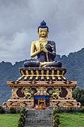 Large Gautama Buddha statue in Buddha Park of Ravangla, Sikkim
 -
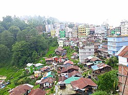 View of Ravangla town
 -
 Ravangla main street
 -
 Tibetan Carpet Factory of Ravangla, Sikkim
 -
 View of the hotels and the Jeep stand


See also
[edit]References
[edit]- ^ "ravangla City Census". censusindia.gov.in. Retrieved 15 September 2015.
- ^ Ravidas, Rajeev. "Sikkim forms Soreng and Pakyong districts, total number rises to six". The Telegraph Online. Retrieved 15 December 2025.
- ^ Rai, IAS, Sarala. "Sikkim Government Gazette" (PDF). Sikkimlrdm.gov.in.
- ^ "Census of India Website : Office of the Registrar General & Census Commissioner, India". censusindia.gov.in. Retrieved 20 July 2021.
External links
[edit]This article related to a location in the Indian state of Sikkim is a stub. You can help Wikipedia by expanding it. |