Île-aux-Moines
| Île-aux-Moines | |
 | |
| Verwàltung | |
|---|---|
| Land | |
| Region | |
| Département | Morbihan (56) |
| Arrondissement | Vannes |
| Kànton | Vannes-2 |
| Kommünàlverbànd | Golfe du Morbihan - Vannes Agglomération |
| Àmtliga Nàma | Île-aux-Moines |
| Maire | Philippe Le Berigot (2014-2020)[1] |
| Code Insee | 56087 |
| Poschtlaitzàhl | 56780 |
| Iiwohner | |
| Iiwohner | 632 |
| Flech | 3,2 km2 |
| Bevelkerungsdicht | 187,81 Iiw./km2 |
| Làg | |
| Koordinate | 47° 35′ 48″ N, 2° 50′ 41″ W / 47.596666666667°N,2.8447222222222°WKoordinate: 47° 35′ 48″ N, 2° 50′ 41″ W / 47.596666666667°N,2.8447222222222°W |
| Heche | 20 m |
 Île-aux-Moines Île-aux-Moines (Frànkrich) | |
| Website | |
| https://www.mairie-ileauxmoines.fr/ | |
Île-aux-Moines (bretonisch Enizenac'h) isch e franzesischi Gmai im Département Morbihan in dr Region Bretagne.
D Gmai ghert zum Kanton Vannes-2 un zum Arrondissement Vannes.
Geografi
[ändere | Quälltäxt bearbeite]Dr Bann umfasst di glychnamig Insle Île-aux-Moines, e sibe Kilometer langi un fimf Kilometer braiti Insle im Golf vu Morbihan, 10 km vu Vannes un 42 km vu Lorient. Dr Bann umfasst d Île-aux-Moines, e sibe Kilometer langi un fimf Kilometer braiti Insle im Golf vu Morbihan, 10 km vu Vannes un 42 km vu Lorient. Dr hegscht Punkt vu dr Insle lyt 31 Meter iber em Meeresspiegel. Zue dr Gmai ghere au d Insle Île Creïzic un e baar chlaini Insle.
Gschicht
[ändere | Quälltäxt bearbeite]Île-aux-Moines isch zum erschte Mol gnännt wore im 9. Jh. as Crialeis (9. Jh.: Enesmanach, 15. Jh.: Isle au(x) Moene(s), 1764: I. aux Moines, 1809: Isle aux Moines).
Verwaltig
[ändere | Quälltäxt bearbeite]Dr Maire vu Île-aux-Moines isch dr Philippe Le Berigot. Île-aux-Moines ghert zum Kommunalverband Golfe du Morbihan - Vannes Agglomération.
Bevelkerigsentwicklig
[ändere | Quälltäxt bearbeite]| Johr | 1962 | 1968 | 1975 | 1982 | 1990 | 1999 | 2008 |
| Yywohner | 748 | 711 | 588 | 590 | 617 | 610 | 573 |
Dialekt
[ändere | Quälltäxt bearbeite]Dr traditionell Dialäkt vu Île-aux-Moines ghert zum Bretonisch.
Kultur un Böuwärch
[ändere | Quälltäxt bearbeite]- Cromlech Kergenan (Staichrais)
- Dolmen Penhap
- Dolmen Kerno
- Dolmen Pointe de Nioul
- Menhir Brouel
- Chilche Saint-Michel
- Kapäll Le Guéric
-
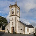
Chilche Saint-Michel -
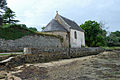
Kapäll Le Guéric -

Dolmen Penhap -
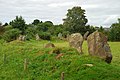
Cromlech Kergenan


Weblink
[ändere | Quälltäxt bearbeite]- https://web.archive.org/web/20181101183221/http://mairie-ileauxmoines.fr/
- Île-aux-Moines uf geobreizh.com (Internet-Archive)
Fueßnote
[ändere | Quälltäxt bearbeite]- ↑ Liste des maires au 25 avril 2014 (data.gouv.fr)