بارله ناساو
لا يزال النص الموجود في هذه الصفحة في مرحلة الترجمة إلى العربية. |
| بارله ناساو | |||
|---|---|---|---|
 |
|||
|
|||
.svg) |
|||
 |
|||
| الإحداثيات | 51°27′00″N 4°56′00″E / 51.45°N 4.9333333333333°E | ||
| تقسيم إداري | |||
| البلد | |||
| التقسيم الأعلى | برابانت الشمالي[1] | ||
| خصائص جغرافية | |||
| المساحة | 76.30 كيلومتر مربع 76.36 كيلومتر مربع |
||
| ارتفاع | 28 متر | ||
| عدد السكان | |||
| عدد السكان | 6899 (1 يناير 2021)[2] | ||
| عدد الأسر | 2874 (1 يناير 2015) | ||
| معلومات أخرى | |||
| منطقة زمنية | ت ع م+01:00 | ||
| الرمز البريدي | 5110 5111 5113 5114 |
||
| رمز جيونيمز | 2759553[3] | ||
| الموقع الرسمي | الموقع الرسمي (الهولندية) | ||
| تعديل مصدري - تعديل | |||


بارله ناساو Baarle-Nassau ![]() ، مدينة تقع في مقاطعة شمال برابنت جنوب هولندا.
، مدينة تقع في مقاطعة شمال برابنت جنوب هولندا.
الطوبوغرافيا
[عدل] خريطة طوبوغرافية هولندية لبلدية بارله ناساو، يونيو 2015، (تقرأ بعد ثلاث نقرات على الخريطة).
جغرافيا
[عدل]الحدود مع بارل هيرتوغ التابعة لبلجيكا
[عدل]ترتبط بارل ناساو ارتباطًا وثيقًا، بحدود معقدة، بالمقتفرات البلجيكية في بارل هيرتوغ. يتكون بارل هيرتوغ من 26 قطعة أرض منفصلة. بصرف النظر عن الطرد الرئيسي، المعروف باسم Zondereigen والذي يقع شمال مدينة Merksplas البلجيكية، هناك 22 مكان بلجيكي في هولندا وثلاثة جيوب أخرى على الحدود الهولندية البلجيكية. هناك أيضًا ستة معازل هولندية تقع داخل أكبر معزل بلجيكي، واحد في ثاني أكبر، وثامن داخل Zondereigen. أصغر طرد بلجيكي، H7، المسمى محليًا De Loversche Akkers، تبلغ مساحته 2,469 متر مربع (26,580 قدم2).
ينجم تعقيد الحدود عن العديد من المعاهدات والاتفاقيات وتبادل الأراضي والمبيعات في العصور الوسطى بين أسياد بريدا ودوقات برابانت. بشكل عام، أصبحت البيئات الزراعية أو المبنية في الغالب من مكونات برابانت، بينما انتقلت الأجزاء الأخرى إلى بريدا. تم التصديق على هذه التوزيعات وتوضيحها كجزء من المستوطنات الحدودية التي تم التوصل إليها خلال معاهدة ماستريخت في عام 1843.
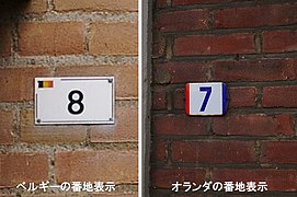
للتوضيح واهتمام السائحين، أصبحت الحدود مرئية في جميع الشوارع بدبابيس حديدية. بهذه الطريقة يتضح دائمًا ما إذا كان الشخص موجودًا في بلجيكا (بارلي-هيرتوغ) أو في هولندا (بارله ناساو). يظهر هذا أيضًا على أرقام المنازل: يختلف نمط أرقام المنازل في كلا البلدين، وغالبًا ما سيجد المرء العلم الهولندي أو البلجيكي بجوار الرقم.


التجمعات السكانية
[عدل]- مدينة بارل نوسو (5,330 نسمة).
- يوليكوتن [الإنجليزية] (1,110 نسمة)
- كاستريلي [الإنجليزية] (199 نسمة)
قائمة المناطق المعزولة حدودياً
[عدل]| التسلسل # والاسم المحلي [4] | المساحة (بالهكتار) | ملاحظات |
|---|---|---|
| 5.3667 | Counter-enclave surrounded by Belgian exclave, H1, in Baarle-Hertog; part of Baarle-Nassau Commune, Netherlands; contains a mix of dwellings and farmland; boundary of N1 and H1 runs through one building | |
| 1.3751 | Counter-enclave surrounded by Belgian exclave, H1, in Baarle-Hertog; part of Baarle-Nassau Commune, Netherlands; contains 8 dwellings | |
| 0.2863 | Counter-enclave surrounded by Belgian exclave, H1, in Baarle-Hertog; part of Baarle-Nassau Commune, Netherlands; boundary of N3 and H1 bisects the loading dock of a liquor store | |
| 1.2324 | Counter-enclave surrounded by Belgian exclave, H1, in Baarle-Hertog; part of Baarle-Nassau Commune, Netherlands; boundary of N4 and H1 runs through a warehouse, with vacant Dutch land to the rear of the warehouse | |
| 1.9212 | Counter-enclave surrounded by Belgian exclave, H1, in Baarle-Hertog; part of Baarle-Nassau Commune, Netherlands; boundary of N5 and H1 runs through a furniture showroom, a shed and a barn | |
| 1.4527 | Counter-enclave surrounded by Belgian exclave, H1, in Baarle-Hertog; part of Baarle-Nassau Commune, Netherlands; consists of farmland with two buildings | |
| 0.5812 | Counter-enclave surrounded by Belgian Oordeel exclave, H8, in Baarle-Hertog; part of Baarle-Nassau Commune, Netherlands; occupies part of a field | |
| 2.8528 | Farmland enclave situated within Zondereigen, Belgium, less than 50 meters south of the Dutch border; part of Baarle-Nassau Commune. |
| التسلسل # والاسم المحلي [4] | المساحة (بالهكتار) | ملاحظات |
|---|---|---|
| 153.6448 | Surrounded by Baarle-Nassau Commune, Netherlands; part of Baarle-Hertog Commune; forms a quadripoint with enclave H2; largest Belgian exclave encompasses six Dutch enclaves; consists of dwellings for the most part with outlying farmland and an industrial area; boundary runs through numerous buildings; contains a portion of the former Turnhout-Tilburg rail line, now a cyclepath | |
| 2.4116 | Surrounded by Baarle-Nassau Commune, Netherlands; part of Baarle-Hertog Commune; consists of farmland with a single point of connection (quadripoint) between enclaves H1 and H2 in the middle of a corn field | |
| 0.3428 | Surrounded by Baarle-Nassau Commune, Netherlands; part of Baarle-Hertog Commune; occupies part of a field; boundary runs through a shed in one instance | |
| 1.476 | Surrounded by Baarle-Nassau Commune, Netherlands; part of Baarle-Hertog Commune; consists of farmland; boundary runs through a house and three sheds | |
| 0.9245 | Surrounded by Baarle-Nassau Commune, Netherlands; part of Baarle-Hertog Commune; consists of farmland with a dwelling | |
| 1.7461 | Surrounded by Baarle-Nassau Commune, Netherlands; part of Baarle-Hertog Commune; has mixed land usage; boundary runs through a warehouse/factory | |
| 0.2469 | Surrounded by Baarle-Nassau Commune, Netherlands; part of Baarle-Hertog Commune; boundary runs through two dwellings, including the middle of one front door (giving it two house numbers: Loveren 2, Baarle-Hertog / Loveren 19, Baarle-Nassau) | |
| 41.8781 | Surrounded by Baarle-Nassau Commune, Netherlands; part of Baarle-Hertog Commune; second largest Belgian exclave, contains a mix of dwellings and farmland; boundary runs through a barn, a dwelling and two businesses | |
| 0.4005 | Surrounded by Baarle-Nassau Commune, Netherlands; part of Baarle-Hertog Commune; boundary runs through a printing factory/warehouse in an industrial area | |
| 0.65 | Surrounded by Baarle-Nassau Commune, Netherlands; part of Baarle-Hertog Commune; consists of farmland | |
| 0.93 | Surrounded by Baarle-Nassau Commune, Netherlands; part of Baarle-Hertog Commune; consists of farmland | |
| 0.2822 | Surrounded by Baarle-Nassau Commune, Netherlands; part of Baarle-Hertog Commune; consists of farmland | |
| 1.5346 | Surrounded by Baarle-Nassau Commune, Netherlands; part of Baarle-Hertog Commune; boundary runs through about 20 dwellings | |
| 0.7193 | Surrounded by Baarle-Nassau Commune, Netherlands; part of Baarle-Hertog Commune; boundary runs through about 13 dwellings | |
| 1.7211 | Surrounded by Baarle-Nassau Commune, Netherlands; part of Baarle-Hertog Commune; boundary runs through about 16 dwellings | |
| 4.4252 | Surrounded by Baarle-Nassau Commune, Netherlands; part of Baarle-Hertog Commune; boundary runs through a house and three sheds, with three turning points inside just one shed | |
| 14.9248 | Surrounded by Baarle-Nassau Commune, Netherlands; part of Baarle-Hertog Commune; rural area contains a portion of the former Turnhout-Tilburg rail line, now a cyclepath | |
| 2.9247 | Surrounded by Baarle-Nassau Commune, Netherlands; part of Baarle-Hertog Commune; consists of farmland | |
| 0.6851 | Surrounded by Baarle-Nassau Commune, Netherlands; part of Baarle-Hertog Commune; consists of several ponds and a field | |
| 1.1681 | Surrounded by Baarle-Nassau Commune, Netherlands; part of Baarle-Hertog Commune; consists of farmland | |
| 1.1845 | Surrounded by Baarle-Nassau Commune, Netherlands; part of Baarle-Hertog Commune; consists of farmland | |
| 0.2632 | Surrounded by Baarle-Nassau Commune, Netherlands, south of the village of Ulicoten; part of Baarle-Hertog Commune; occupies part of a field; nationality was contested from the 1830s until 1995 (remained unallocated to either country in boundary treaty of 26 April 1974) |
معرض الصور
[عدل]-
 Baarle-Nassau, church
 -
 Baarle-Nassau, town hall
 -
 Grensovergang Poppel-Baarle
 -
 Baarle-Nassau, bij Singel, water pump
 -

-

-
-

-
-


المصادر
[عدل]- ^ https://gemeentegeschiedenis.nl.
{{استشهاد ويب}}:|url=بحاجة لعنوان (مساعدة) والوسيط|title=غير موجود أو فارغ (من ويكي بيانات) (مساعدة) - ^ Kerncijfers wijken en buurten 2021، 6 أغسطس 2021، QID:Q167086
- ^ GeoNames (بالإنجليزية), 2005, QID:Q830106
- ^ ا ب Whyte، Brendan (2004). "En Territoire Belge et à Quarante Centimètres de la Frontière" An historical and documentary study of the Belgian and Dutch enclaves of Baarle-Hertog and Baarle-Nassau. The University of Melbourne, School of Anthropology, Geography and Environmental Studies. ISBN:0-7340-3032-0.
مصادر خارجية
[عدل]- الموقع الرسمي لبارله ناساو (بالهولندية)
- الموقع الرسمي لبارله هيرتوخ (بالهولندية)
- The Baarle Enclaves outlined with Maps
- Photograph of H-22, the smallest enclave of B.-Hertog
- Baarle-Nassau / Baarle-Hertog (with maps)
- Photos from Baarle-Nassau/Hertog
- English Website about the Baarle Enclaves / with maps [Dead link]
- Dutch pages about Baarle-Hertog and Baarle-Nassau / with maps
- Page with various pictures of border curiosities in the town
 |
ألفن- كام |
| ||
| رافيلس (بلجيكا- أنتفيرب) | هوخستراتن (بلجيكا- أنتفيرب) | |||
| ||||
| تورنهاوت (بلجيكا- أنتفيرب) | ميركسبلاس (بلجيكا- أنتفيرب)، بارله- هيرتوخ (بلجيكا- أنتفيرب) |


| دولية | |
|---|---|
| وطنية | |
| جغرافية | |