Crécy-la-Chapelle
| Crécy-la-Chapelle | ||
|---|---|---|

|
||
| Stoot | Fraungreich | |
| Región | Île-de-France | |
| Département (Nr.) | Seine-et-Marne (77) | |
| Arrondissement | Meaux | |
| Kantón | Serris | |
| Gmoandvabaund | Pays Créçois | |
| Kóoerdinaten | 48° 52′ N, 2° 54′ O | |
| Heechen | 45–157 m | |
| Flächen | 15,43 km² | |
| Eihwóner | 4.669 (1. Jénner 2018) | |
| Bevëkarungsdichten | 303 Eihw./km² | |
| Póstloatzoi | 77580 | |
| INSEE-Code | 77142 | |
| Website | http://www.crecylachapelle.eu/ | |
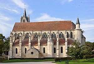
 Kiach Notre-Dame in Crécy-la-Chapelle | ||
Crécy-la-Chapelle is a franzesische Gmoa mid 4669 Eihwohna (Stond: 1. Jenna 2018) im Département Seine-et-Marne in da Region Île-de-France. Se ghead zan Arrondissement Meaux und zan Kanton Serris.
Geografie
[Werkeln | Am Gwëntext werkeln]De Stod liegd om Ufa van Fluss Grand Morin.
Ortstei: Crécy Bourg, Montbarbin, Serbonne, La Chapelle, Libernon, Mongrolle, Ferolles, Montaudier
Nochboagmoana: Bouleurs, Villiers-sur-Morin, Couilly-Pont-aux-Dames, Voulangis, Guérard, Maisoncelles-en-Brie
Gschicht
[Werkeln | Am Gwëntext werkeln]De Gmoa Crécy-la-Chapelle is om 1. Oktoba 1972 aus de Gmoan: Crécy-en-Brie und La-Chapelle-sur-Crécy buidd worn. Da Nam Crécy tritt easchtmos im 7. Joarhundad ois Criscecus, Crideciacavico oda Creciacum af. Im 9. Joarhundad is de easchte Festung baud worn (schau: Grofschoft Crécy).
Bevejkarungsentwicklung
[Werkeln | Am Gwëntext werkeln]| Joar | 1962 | 1968 | 1975 | 1982 | 1990 | 1999 | 2007 | 2017 |
| Einwohna | 1849 | 1928 | 2193 | 2413 | 3222 | 3851 | 4056 | 4531 |
| Quejn: Cassini und INSEE | ||||||||
- INSEE: Bevölkerungsentwicklung von Crécy-la-Chapelle 1962-1999 (Seite nicht mehr abrufbar; Suche in Webarchiven)
Sengswiadigkeitn
[Werkeln | Am Gwëntext werkeln]- Stiftskiach Notre-Dame-de-l’Assomption
- Belfried, eabaud 1865
- Maison Corot
Städtpartnaschoftn
[Werkeln | Am Gwëntext werkeln]Literatua
[Werkeln | Am Gwëntext werkeln]- Le Patrimoine des Communes de la Seine-et-Marne. Flohic Editions, Band 1, Paris 2001, ISBN 2-84234-100-7, S. 360–365.
Im Netz
[Werkeln | Am Gwëntext werkeln]- Crécy-la-Chapelle bei annuaire-mairie.fr (franzesisch)
