Arrondissement de Schwandorf

Arrondissement de Schwandorf
Landkreis Schwandorf
Blason de Arrondissement de Schwandorf
Héraldique
Drapeau de Arrondissement de Schwandorf
Localisation
Administration
Pays Drapeau de l'Allemagne Allemagne
Land Drapeau de Bavière Bavière
District
(Regierungsbezirk)
Haut-Palatinat
Chef-lieu Schwandorf
Villes principales Schwandorf, Burglengenfeld
Préfet
(Landrat)
Volker Liedtke
Partis au pouvoir SPD
Code arrondissemental
(Kreisschlüssel)
09 3 76
Immatriculation BUL, NAB, NEN, OVI, ROD, SAD
Communes 33
Démographie
Population 149 239 hab. (31 décembre 2021)
Densité 102 hab./km2
Géographie
Superficie 1 467 km2
Localisation
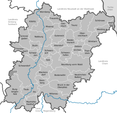
Localisation de Arrondissement de Schwandorf
Liens
Site web www.landkreis-schwandorf.de

L'arrondissement de Schwandorf est un arrondissement (Landkreis en allemand) de Bavière (Allemagne) situé dans le district (Regierungsbezirk en allemand) du Haut-Palatinat. Son chef lieu est Schwandorf.

Villes, communes & communautés d'administration

[modifier | modifier le code]

(nombre d'habitants en 2006)

Städte

  1. Burglengenfeld (12 308)
  2. Maxhütte-Haidhof (10 497)
  3. Nabburg (6 072)
  4. Neunburg vorm Wald (8 229)
  5. Nittenau (8 508)
  6. Oberviechtach (4 982)
  7. Pfreimd (5 553)
  8. Schönsee (2 721)
  9. Schwandorf, Große Kreisstadt (30 284)
  10. Teublitz (7 452)


Märkte

  1. Bruck in der Oberpfalz (4 443)
  2. Neukirchen-Balbini (1 146)
  3. Schwarzenfeld (6 252)
  4. Schwarzhofen (1 493)
  5. Wernberg-Köblitz (5 778)
  6. Winklarn (1 446)

Gemeinden

  1. Altendorf (951)
  2. Bodenwöhr (4 031)
  3. Dieterskirchen (1 059)
  4. Fensterbach (2 479)
  5. Gleiritsch (669)
  6. Guteneck (881)
  7. Niedermurach (1 305)
  8. Schmidgaden (2 905)
  9. Schwarzach bei Nabburg (1 553)
  10. Stadlern (636)
  11. Steinberg am See (1 813)
  12. Stulln (1 691)
  13. Teunz (1 997)
  14. Thanstein (998)
  15. Trausnitz (989)
  16. Wackersdorf (5 036)
  17. Weiding (595)

Gemeindefreie Gebiete (41,02 km²)

  1. Einsiedler und Walderbacher Forst (18,70 km²)
  2. Östlicher Neubäuer Forst (15,71 km²)
  3. Wolferlohe (6,61 km²)

Verwaltungsgemeinschaften

  1. Nabburg
    (Ville de Nabburg et communes Altendorf et Guteneck)
  2. Neunburg vorm Wald
    (Märkte Neukirchen-Balbini et Schwarzhofen et communes Dieterskirchen et Thanstein)
  3. Oberviechtach
    (Markt Winklarn et communes Gleiritsch, Niedermurach et Teunz)
  4. Pfreimd
    (Ville de Pfreimd et commune Trausnitz)
  5. Schönsee
    (Ville de Schönsee et communes Stadlern et Weiding)
  6. Schwarzenfeld
    (Markt Schwarzenfeld et communes Schwarzach b.Nabburg et Stulln)
  7. Wackersdorf
    (Communes Steinberg et Wackersdorf)