Arkansasrivier
| Arkansasrivier | |
|---|---|
 | |
|
Die stroomgebied van die Arkansasrivier. | |
| Oorsprong | saamvloei van East Fork Arkansasrivier en Tennessee Creek in die Sawatch Range naby Leadville, Colorado (Verenigde State) |
| Monding | Franklin Township, Desha County, naby Napoleon, Arkansas Mississippirivier |
| Stroomgebied | Colorado, Kansas, Oklahoma, Arkansas (Verenigde State) |
| Lengte | 2 364 km[1] (1 469 myl) |
| Oorspronghoogte | 2 965 m (9 728 vt) |
| Mondinghoogte | 33 m (108 vt) |
| Gemiddelde afloop | 40 517 m³/s[2] (1 147 vt³/s) |
| Stroomgebiedopp. | 435 123 km² (168 002 myl²) |
| Kaart van die Arkansasrivier-bekken in Noord-Amerika.
| |
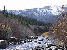
Die Arkansasrivier (Engels: Arkansas River) is 'n groot oos-vloeiende rivier in Noord-Amerika. Die rivier, met 'n lengte van 'n 2 364 km, ontspring in die Sawatch Range in die Rotsgebergte in Colorado. Dit is een van die grootste sytakke van die Mississippirivier en die sesde grootste rivier in die Verenigde State.
Die Arkansasrivier loop deur die suid-westelike Amerikaanse deelstate Colorado, Kansas, Oklahoma en Arkansas asook deur die volgende stede: Little Rock, Pueblo, Wichita en Tulsa. Die grootste sytak van die Arkansasrivier is die Canadian rivier.
Die rivier het vanaf die Adams-Onís-Verdrag in 1821 tot die Anneksasie van die Republiek van Texas in 1845 of die Verdrag van Guadalupe Hidalgo in 1848 tussen sy boloop en die 100ste Breedtegraad die grens tussen Meksiko en die Verenigde State gevorm.
Naamvariasies
[wysig | wysig bron]

Die rivier het verskeie naamvariasies:
Verwysings
[wysig | wysig bron]- ↑ (en) "USGS Gage #07258000 on the Arkansas River near Dardanelle, AR (monthly flow data)". Water Resources of the United States. U.S. Geological Survey. Geargiveer vanaf die oorspronklike op 11 Desember 2016. Besoek op 13 Junie 2014.
- ↑ 3,0 3,1 3,2 3,3 3,4 3,5 3,6 (en) Rydjord, John. Kansas Place Names, Norman, Okla: University of Oklahoma Press, 1972. Geographic Name Information including origins, organized by subject categories
- ↑ 4,0 4,1 4,2 4,3 (en) U.S. Geological Survey. Geographic Names Phase I data compilation (1976–1981). 31-Dec-1981. Primarily from U.S. Geological Survey 1:24,000-scale topographic maps (or 1:25K, Puerto Rico 1:20K) and from U.S. Board on Geographic Names files. In some instances, from 1:62,500 scale or 1:250,000 scale maps
- ↑ (en) Flores, Dan L., editor. Jefferson and Southwestern Exploration. Norman, Oklahoma: University of Oklahoma Press, 1984. bl. 8
- ↑ 6,0 6,1 6,2 (en) U.S. Geological Survey. Geographic Names Phase I data compilation (1976–1981). 31-Dec-1981. Primarily from U.S. Geological Survey 1:24,000-scale topographic maps (or 1:25K, Puerto Rico 1:20K) and from U.S. Board on Geographic Names files. In some instances, from 1:62,500 scale or 1:250,000 scale maps
- ↑ (en) DuGard, Rene C. Dictionary of French Place Names in the U.S.A. Editions Des Deux Mondes Et Slavuta, 1986, 431 bl. 9
- ↑ (en) Emporia Chamber of Commerce. City of Emporia, Kansas. n.p.:n.d.
- ↑ (en) Arnold, Morris S. Colonial Arkansas, 1686–1804: A Social and Cultural History. Fayetteville, Arkansas: University of Arkansas Press, 1991. bl. 190
- ↑ 10,0 10,1 (en) McCoy, Sondra Van Meter and Jan Hults. 1001 Kansas Place Names. Lawrence, Ks.: University Press of Kansas, 1989, bl. 223. bl. 9
- ↑ (en) Allsop, Fred W. Folklore of Romantic Arkansas. 2 vols. New York, New York: Grolier Society, 1931. v1/bl. 45
- ↑ (en) Allsop, Fred W. Folklore of Romantic Arkansas. 2 vols. New York, New York: Grolier Society, 1931. v1/bl. 36
- ↑ (en) McCoy, Sondra Van Meter and Jan Hults. 1001 Kansas Place Names. Lawrence, Ks.: University Press of Kansas, 1989, bl. 223. bl. 9
- ↑ (fr) L'Isle Guillaume de. Carte de la Louisianurs du Mississipi, Atlas Nouveau, Contenant Toutes Les Parties du Monde, Ou font exactement Remarquees les Empires, Monarchies, Royaumes, Etats, Republiques, etc. , Amsterdam: chez Jean Covens and Corneille Mortier, 1733 (no scale). Provided an historical reference based presumably on French explorations
- ↑ (en) Penicaut, Andre. Fleur de Lys and Calumet: Being the Penicaut Narrative of French Adventure in Louisiana. Translated and edited by Richebourg Gaillard McWilliams. Tuscaloosa, Alabama: University of Alabama Press, 1988. bl. 34
Eksterne skakels
[wysig | wysig bron] Wikimedia Commons het meer media in die kategorie Arkansasrivier.
- (en) "Arkansas River". Encyclopædia Britannica. Besoek op 30 Augustus 2020.

