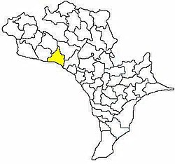
Ibrahimpatnam (mandal), Krishna
| Ibrahimpatnam mandal | |
|---|---|
| — Mandal — | |
 Mandal map of Krishna district showing Ibrahimpatnam mandal (in yellow) | |
| Location in Andhra Pradesh, India | |
| Quốc gia | Ấn Độ |
| Bang | Andhra Pradesh |
| Huyện | Krishna |
| Headquarters | Ibrahimpatnam |
| Diện tích[1] | |
| • Tổng cộng | 104,81 km2 (4,047 mi2) |
| Dân số (2011)[2] | |
| • Tổng cộng | 103.559 |
| • Mật độ | 9,9/km2 (26/mi2) |
| Languages | |
| • Chính thức | Telugu |
| Múi giờ | IST (UTC+5:30) |
| Biển số xe | AP |
Ibrahimpatnam mandal là một trong 50 mandal thuộc huyện Krishna, bang Andhra Pradesh, Ấn Độ.[1][3] The mandal is located on the banks of Krishna River and is bounded by Kanchikacherla, Veerullapadu, G. Konduru and Vijayawada (rural) mandals.[4] The mandal is also a part of the Andhra Pradesh Capital Region under the jurisdiction of APCRDA.[5]
Chú thích
[sửa | sửa mã nguồn]- ^ a b “District Census Handbook - Krishna” (PDF). Census of India. tr. 16,310. Truy cập ngày 6 tháng 2 năm 2016.
- ^ “Census 2011”. The Registrar General & Census Commissioner, India. Truy cập ngày 12 tháng 9 năm 2014.
- ^ “Krishna District Mandals” (PDF). Census of India. tr. 492, 526. Truy cập ngày 21 tháng 1 năm 2015.
- ^ “Mandals in Krishna district”. aponline.gov.in. Bản gốc lưu trữ ngày 13 tháng 12 năm 2014. Truy cập ngày 15 tháng 9 năm 2014.
- ^ “Andhra Pradesh Capital Region Development Authority Act, 2014” (PDF). News19. Municipal Administration and Urban Development Department. ngày 30 tháng 12 năm 2014. Bản gốc (PDF) lưu trữ 18 Tháng 2 2015. Truy cập ngày 9 tháng 2 năm 2015. Kiểm tra giá trị ngày tháng trong:
|archive-date=(trợ giúp)
Tham khảo
[sửa | sửa mã nguồn]Chúng tôi bán
 GIẢM
40%
5.584 ₫
9.359 ₫
 GIẢM
16%
314.000 ₫
374.000 ₫
 GIẢM
30%
28.000 ₫
40.000 ₫
 GIẢM
17%
100.000 ₫
120.000 ₫


![[Review sách] Những giấc mơ ở hiệu sách Morisaki - Chốn bình yên gắn kết tâm hồn đồng điệu](https://images.spiderum.com/sp-images/1ddadd90a2d511ed9e5b8be9d59aed6c.jpeg)