Wiki Article
Portal:World
Nguồn dữ liệu từ Wikipedia, hiển thị bởi DefZone.Net
The World Portal


The world is the totality of entities, the whole of reality, or everything that exists. The nature of the world has been conceptualized differently in different fields. Some conceptions see the world as unique, while others talk of a "plurality of worlds". Some treat the world as one simple object, while others analyze the world as a complex made up of parts.
In scientific cosmology, the world or universe is commonly defined as "the totality of all space and time; all that is, has been, and will be". Theories of modality talk of possible worlds as complete and consistent ways how things could have been. Phenomenology, starting from the horizon of co-given objects present in the periphery of every experience, defines the world as the biggest horizon, or the "horizon of all horizons". In philosophy of mind, the world is contrasted with the mind as that which is represented by the mind.
Theology conceptualizes the world in relation to God, for example, as God's creation, as identical to God, or as the two being interdependent. In religions, there is a tendency to downgrade the material or sensory world in favor of a spiritual world to be sought through religious practice. A comprehensive representation of the world and our place in it, as is found in religions, is known as a worldview. Cosmogony is the field that studies the origin or creation of the world, while eschatology refers to the science or doctrine of the last things or of the end of the world.
In various contexts, the term "world" takes a more restricted meaning associated, for example, with the Earth and all life on it, with humanity as a whole, or with an international or intercontinental scope. In this sense, world history refers to the history of humanity as a whole, and world politics is the discipline of political science studying issues that transcend nations and continents. Other examples include terms such as "world religion", "world language", "world government", "world war", "world population", "world economy", or "world championship". (Full article...)
Selected articles -
-

The Scientific Revolution of the 16th and 17th centuries in Europe was an irreversible break with the natural philosophy that had preceded it, fundamentally changing how the natural world was investigated and understood. The New Science that emerged departed from previous Greek conceptions and traditions, was more mechanistic in its worldview and more integrated with mathematics, and was focused on the acquisition and interpretation of new evidence.
The Scientific Revolution is a convenient boundary between ancient thought and modern science. While the period is frequently said to have begun in 1543 with the printings of De humani corporis fabrica (On the Workings of the Human Body) by Andreas Vesalius and De Revolutionibus (On the Revolutions of the Heavenly Spheres) by Nicolaus Copernicus, the SN 1572 supernova has also been suggested as its beginning. The period culminated with the publication of the Philosophiæ Naturalis Principia Mathematica in 1687 by Isaac Newton. (Full article...) -

World GDP per capita between 1500 and 2003
The world economy or global economy is the economy of all humans in the world, referring to the global economic system, which includes all economic activities conducted both within and between nations, including production, consumption, economic management, work in general, financial transactions and trade of goods and services. In some contexts, the two terms are distinct: the "international" or "global economy" is measured separately and distinguished from national economies, while the "world economy" is simply an aggregate of the separate countries' measurements. Beyond the minimum standard concerning value in production, use and exchange, the definitions, representations, models and valuations of the world economy vary widely. It is inseparable from the geography and ecology of planet Earth.
It is common to limit questions of the world economy exclusively to human economic activity, and the world economy is typically judged in monetary terms, even in cases in which there is no efficient market to help valuate certain goods or services, or in cases in which a lack of independent research, genuine data or government cooperation makes calculating figures difficult. Typical examples are illegal drugs and other black market goods, which by any standard are a part of the world economy, but for which there is, by definition, no legal market of any kind. (Full article...) -
The Internet originated in the efforts of scientists and engineers to build and interconnect computer networks. The Internet Protocol Suite, the set of rules used to communicate between networks and devices on the Internet, arose from research and development in the United States and involved international collaboration, particularly with researchers in the United Kingdom and France.
Computer science was an emerging discipline in the late 1950s that began to consider time-sharing between computer users, and later, the possibility of achieving this over wide area networks. J. C. R. Licklider articulated the idea of a universal network at the Information Processing Techniques Office (IPTO) of the United States Department of Defense (DoD) Advanced Research Projects Agency (ARPA). Independently, Paul Baran at the RAND Corporation proposed a distributed network based on data in message blocks in the early 1960s, and Donald Davies conceived of packet switching in 1965 at the National Physical Laboratory (NPL), proposing a national commercial data network in the United Kingdom. (Full article...) -

The World Health Organization in Geneva, Switzerland
Global health is the health of populations in a worldwide context; it has been defined as "the area of study, research, and practice that places a priority on improving health and achieving equity in health for all people worldwide". Problems that transcend national borders or have a global political and economic impact are often emphasized. Thus, global health is about worldwide health improvement (including mental health), reduction of disparities, and protection against global threats that disregard national borders, including the most common causes of human death and years of life lost from a global perspective.
Global health is not to be confused with international health, which is defined as the branch of public health focusing on developing nations and foreign aid efforts by industrialized countries. (Full article...) -

Sand dunes in the Rub' al Khali ("Empty quarter") of Arabia
A desert is a landscape where little precipitation occurs and, consequently, living conditions create unique biomes and ecosystems. The lack of vegetation exposes the unprotected surface of the ground to denudation. About one-third of the land surface of the Earth is arid or semi-arid. This includes much of the polar regions, where little precipitation occurs, and which are sometimes called polar deserts or "cold deserts". Deserts can be classified by the amount of precipitation that falls, by the temperature that prevails, by the causes of desertification or by their geographical location.
Deserts are formed by weathering processes as large variations in temperature between day and night strain the rocks, which consequently break into pieces. Although rain seldom occurs in deserts, there are occasional downpours that can result in flash floods. Rain falling on hot rocks can cause them to shatter, and the resulting fragments and rubble strewn over the desert floor are further eroded by the wind. This picks up particles of sand and dust, which can remain airborne for extended periods – sometimes causing the formation of sand storms or dust storms. Wind-blown sand grains striking any solid object in their path can abrade the surface. Rocks are smoothed down, and the wind sorts sand into uniform deposits. The grains end up as level sheets of sand or are piled high in billowing dunes. Other deserts are flat, stony plains where all the fine material has been blown away and the surface consists of a mosaic of smooth stones, often forming desert pavements, and little further erosion occurs. Other desert features include rock outcrops, exposed bedrock and clays once deposited by flowing water. Temporary lakes may form and salt pans may be left when waters evaporate. There may be underground water sources in the form of springs and seepages from aquifers. Where these are found, oases can occur. (Full article...) -
The International Monetary Fund (IMF) is an international financial institution and a specialized agency of the United Nations, headquartered in Washington, D.C. It consists of 191 member countries, and its stated mission is "working to foster global monetary cooperation, secure financial stability, facilitate international trade, promote high employment and sustainable economic growth, and reduce poverty around the world." The IMF acts as a lender of last resort to its members experiencing actual or potential balance of payments crises.
Established in July 1944 at the Bretton Woods Conference based on the ideas of Harry Dexter White and John Maynard Keynes, the IMF came into formal existence in 1945 with 29 member countries and the goal of reconstructing the international monetary system. For its first three decades, the IMF oversaw the Bretton Woods system of fixed exchange rate arrangements. Following the collapse of this system in 1971, the Fund's role shifted to managing balance-of-payments difficulties and international financial crises, becoming a key institution in the era of globalization. (Full article...) -

Among the various cradles of civilization is Ancient Egypt. Pictured are the Giza Pyramids.
A cradle of civilization is a location and a culture where civilization was developed independently of other civilizations in other locations. A civilization is any complex society characterized by the development of the state, social stratification, urbanization, and symbolic systems of communication beyond signed or spoken languages (namely, writing systems and graphic arts).
Scholars generally acknowledge six cradles of civilization: Mesopotamia, Ancient Egypt, Ancient India and Ancient China are believed to be the earliest in Afro-Eurasia, while the Caral–Supe civilization of coastal Peru and the Olmec civilization of Mexico are believed to be the earliest in the Americas. All of the cradles of civilization depended upon agriculture for sustenance (except possibly Caral–Supe which may have depended initially on marine resources). All depended upon farmers producing an agricultural surplus to support the centralized government, political leaders, religious leaders, and public works of the urban centers of the early civilizations. (Full article...)

.jpg)


General images -
-
 Notre-Dame de Paris, France
 -

-
 An artist's impression of ice age Earth at glacial maximum. (from History of Earth)
 -
 Great Pyramids of Giza, Egypt
 -
 Earth's land use for human agriculture in 2019 (from Earth)
 -
 Artist's impression of the enormous collision that probably formed the Moon (from History of Earth)
 -
 Pillar erected by Ashoka, a Mauryan Emperor in India
 -
 Lithified stromatolites on the shores of Lake Thetis, Western Australia. Archean stromatolites are the first direct fossil traces of life on Earth. (from History of Earth)
 -
-
 A composite image of Earth, with its different types of surface discernible: Earth's surface dominating Ocean (blue), Africa with lush (green) to dry (brown) land and Earth's polar ice in the form of Antarctic sea ice (grey) covering the Antarctic or Southern Ocean and the Antarctic ice sheet (white) covering Antarctica. (from Earth)
 -
 Japanese depiction of a Portuguese carrack, a result of globalizing maritime trade
 -
 COVID-19 pandemic, 2020 (from Human history)
 -
 Steam Yatch Gondola on Coniston Water. The geography humans had access to impacted their socio-economic condition. (from Human history)
 -

-
 Taj Mahal, Mughal Empire, India
 -
 Artist's conception of Hadean Eon Earth, when it was much hotter and inhospitable to all forms of life. (from History of Earth)
 -
 The replicator in virtually all known life is deoxyribonucleic acid. DNA is far more complex than the original replicator and its replication systems are highly elaborate. (from History of Earth)
 -
-
 A depiction of the early Solar System's protoplanetary disk from which Earth and other Solar System bodies were formed (from Earth)
 -
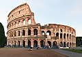 The Colosseum in Rome (from Human history)
 -
 Chloroplasts in the cells of a moss (from History of Earth)
 -

-
 Artist's rendition of an oxinated fully-frozen Snowball Earth with no remaining liquid surface water. (from History of Earth)
 -
 Olmec colossal head, now at the Museo de Antropología de Xalapa
 -
 Successive dispersals of Homo erectus (yellow), Homo neanderthalensis (ochre) during Out of Africa I and Homo sapiens (red, Out of Africa II), with the numbers of years since they appeared before present. (from Human history)
 -
 Geologic map of North America, color-coded by age. From most recent to oldest, age is indicated by yellow, green, blue, and red. The reds and pinks indicate rock from the Archean.
 -
 European migrations by mostly Germanic peoples, 2nd–6th centuries (from Human history)
 -
 Hands at the Cuevas de las Manos upon Río Pinturas, near the town of Perito Moreno in Santa Cruz Province, Argentina. The art in the cave dates between 13,000–9,000 BP. This dates the art to during or before the Neolithic Era. (from Human history)
 -
 An animation of the changing density of productive vegetation on land (low in brown; heavy in dark green) and phytoplankton at the ocean surface (low in purple; high in yellow) (from Earth)
 -
 Cross-section through a liposome (from History of Earth)
 -
 A computer-generated image mapping the prevalence of artificial satellites and space debris around Earth in geosynchronous and low Earth orbit (from Earth)
 -
 Dinosaurs were the dominant terrestrial vertebrates throughout most of the Mesozoic (from History of Earth)
 -
 The first airplane, the Wright Flyer, flew on 17 December 1903.
 -
 Fall of the Berlin Wall, 1989
 -
 Carving of Persian and Median soldiers, Persepolis, Achaemenid Empire, 5th century BCE
 -
 Pale orange dot, an impression of Early Earth, featuring its tinted orange methane-rich early atmosphere (from Earth)
 -
 Artist's impression of Earth during the later Archean, the largely cooled planetary crust and water-rich barren surface, marked by volcanoes and continents, features already round microbialites. The Moon, still orbiting Earth much closer than today and still dominating Earth's sky, produced strong tides. (from History of Earth)
 -

-
 Cuneiform inscription, eastern Turkey
 -
 Artist's conception of Devonian flora (from History of Earth)
 -
 13th-century French historiated initial with the three classes of medieval society: those who prayed (the clergy), those who fought (the knights), and those who worked (the peasantry)
 -
 Ming dynasty section, Great Wall of China
 -
 Angkor Wat temple complex, Cambodia, early 12th century
 -
 A view of Earth with different layers of its atmosphere visible: the troposphere with its clouds casting shadows, a band of stratospheric blue sky at the horizon, and a line of green airglow of the lower thermosphere around an altitude of 100 km, at the edge of space (from Earth)
 -
 Earth's western hemisphere showing topography relative to Earth's center instead of to mean sea level, as in common topographic maps (from Earth)
 -
 Battle during the 1281 Mongol invasion of Japan
 -
 Machu Picchu, Inca Empire, Peru
 -
 Earth's night-side upper atmosphere appearing from the bottom as bands of afterglow illuminating the troposphere in orange with silhouettes of clouds, and the stratosphere in white and blue. Next the mesosphere (pink area) extends to the orange and faintly green line of the lowest airglow, at about one hundred kilometers at the edge of space and the lower edge of the thermosphere (invisible). Continuing with green and red bands of aurorae stretching over several hundred kilometers. (from Earth)
 -
 Obelisk of Axum, Ethiopia
 -
 Artist's impression of a Hadean landscape with the relatively newly formed Moon still looming closely over Earth and both bodies sustaining strong volcanism. (from History of Earth)
 -
 Standing Buddha from Gandhara, 2nd century CE
 -
 Change in average surface air temperature and drivers for that change. Human activity has caused increased temperatures, with natural forces adding some variability. (from Earth)
 -
 Pangaea was a supercontinent that existed from about 300 to 180 Ma. The outlines of the modern continents and other landmasses are indicated on this map. (from History of Earth)
 -
 Portrait of Alfraganus in the Compilatio astronomica, 1493. Islamic astronomers began just before the 9th century to collect and translate Indian, Persian and Greek astronomical texts, adding their own astronomy and enabling later, particularly European astronomy to build on. Symbolic for the post-classical period, a period of an increasing trans-regional literary culture, particularly in the sciences, spreading and building on methods of science. (from Human history)
 -
 A 580 million year old fossil of Spriggina floundensi, an animal from the Ediacaran period. Such life forms could have been ancestors to the many new forms that originated in the Cambrian Explosion. (from History of Earth)
 -
 Tracy Caldwell Dyson, a NASA astronaut, observing Earth from the Cupola module at the International Space Station on 11 September 2010 (from Earth)
 -
 Chennakesava Temple, Belur, India
 -
 Florence, birthplace of the Italian Renaissance
 -
 Benin Bronze head from Nigeria
 -
The pale orange dot, an artist's impression of the early Earth which might have appeared orange through its hazy methane rich prebiotic second atmosphere. Earth's atmosphere at this stage was somewhat comparable to today's atmosphere of Titan. (from History of Earth)
-
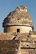
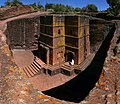 One of the eleven Rock-hewn Churches of Lalibela constructed during the Zagwe dynasty in Ethiopia (from Human history)
 -
 Earth's history with time-spans of the eons to scale. Ma means "million years ago", Ga means "billion years ago". (from History of Earth)
 -
 A reconstruction of Pannotia (550 Ma). (from History of Earth)
 -
-

-

-
 Satellite time lapse imagery of Earth's rotation showing axis tilt (from Earth)
 -
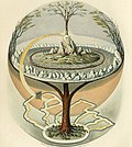 Yggdrasil, an attempt to reconstruct the Norse world tree which connects the heavens, the world, and the underworld. (from World)
 -
 A schematic view of Earth's magnetosphere with solar wind flowing from left to right (from Earth)
 -
 A composite image of artificial light emissions at night on a map of Earth (from Earth)
 -
An impression of the Archean, the eon after Earth's formation, featuring round stromatolites, which are early oxygen-producing forms of life from billions of years ago. After the Late Heavy Bombardment, Earth's crust had cooled, its water-rich barren surface is marked by continents and volcanoes, with the Moon still orbiting Earth half as far as it is today, appearing 2.8 times larger and producing strong tides. (from Earth)
-
 A map of heat flow from Earth's interior to the surface of Earth's crust, mostly along the oceanic ridges (from Earth)
 -
 A banded iron formation from the 3.15 Ga Moodies Group, Barberton Greenstone Belt, South Africa. Red layers represent the times when oxygen was available; gray layers were formed in anoxic circumstances. (from History of Earth)
 -
 Vitruvian Man, c. 1490 by Leonardo da Vinci, epitomizes the advances in art and science seen during the Renaissance. (from History of Earth)
 -
 Trilobites first appeared during the Cambrian period and were among the most widespread and diverse groups of Paleozoic organisms. (from History of Earth)
 -
 An artist's rendering of a protoplanetary disk (from History of Earth)
 -
 A view of Earth with its global ocean and cloud cover, which dominate Earth's surface and hydrosphere; at Earth's polar regions, its hydrosphere forms larger areas of ice cover. (from Earth)
 -
 Graph showing range of estimated partial pressure of atmospheric oxygen through geologic time (from History of Earth)
 -
 A pillar at Neolithic Göbekli Tepe
 -
 Earth's axial tilt causing different angles of seasonal illumination at different orbital positions around the Sun (from Earth)
 -
 Tiktaalik, a fish with limb-like fins and a predecessor of tetrapods. Reconstruction from fossils about 375 million years old. (from History of Earth)
 -

-
 A reconstruction of human history based on fossil data. (from History of Earth)
 -
 Last Moon landing: Apollo 17 (1972)
 -
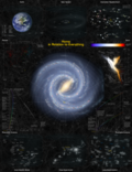
 Image of the physical world, captured by the Hubble Space Telescope (from World)
 -

-

-
 The Historian by E. Irving Couse, 1902The Indigenous artist is painting the story of a battle with American Soldiers. (from Human history)

.svg)


.jpg)


.png)


.jpeg)


.jpg)


.jpg)
Megacities of the world -

Guangzhou is the capital and largest city of the Guangdong province of southern China. Located on the Pearl River, about 120 kilometres (75 mi) northwest of Hong Kong and 145 kilometres (90 mi) north of Macau, Guangzhou has a history of over 2,200 years and was a major terminus of the Silk Road.
The port of Guangzhou serves as transportation hub. Guangzhou is also one of China's three largest cities. For a long time, it was the only Chinese port accessible to most foreign traders. Guangzhou was captured by the British during the First Opium War and no longer enjoyed a monopoly after the war. Consequently it lost trade to other ports such as Hong Kong and Shanghai, but continued to serve as a major entrepôt. Following the Second Battle of Chuenpi in 1841, the Treaty of Nanking was signed between Sir Robert Peel on behalf of Queen Victoria and Lin Zexu on behalf of Emperor Xuanzong and ceded Hong Kong to the United Kingdom on 26 January 1841 after the agreement of the Convention of Chuenpi. (Full article...)
Did you know -

- ... that as many as 35 million soldiers became prisoners of war in World War II, according to some estimates?
- ... that former German chancellor Angela Merkel's grandfather likely fought against Germany in World War I?
- ... that from 1853 to 1855 the State Emigrant Refuge and Hospital on Wards Island in New York City was the largest hospital complex in the world?
- ... that the themes of Somuk's artwork range from the bombing of his island during World War II to the origin of trees and plants?
- ... that Actinote zikani is one of only two butterflies on the IUCN's list of the 100 most threatened species?
- ... that after an earthquake wiped out Shaizar's ruling family, crusaders tried to seize the city but quarreled and left?
- ... that Dreamtime is one of the world's most famous bouldering routes?
- ... that the British Army deployed companies of aliens to France during the First World War?
Countries of the world -

Lithuania, officially the Republic of Lithuania, is a country in the Baltic region of Europe. It is one of three Baltic states and lies on the eastern shore of the Baltic Sea, bordered by Latvia to the north, Belarus to the east and south, Poland to the south, and the Russian semi-exclave of Kaliningrad Oblast to the southwest, with a maritime border with Sweden to the west. Lithuania covers an area of 65,300 km2 (25,200 sq mi), and has a population of 2.9 million. Its capital and largest city is Vilnius; other major cities include Kaunas, Klaipėda, Šiauliai and Panevėžys. Lithuanians are the titular nation, belong to the ethnolinguistic group of Balts, and speak Lithuanian.
For millennia, the southeastern shores of the Baltic Sea were inhabited by various Baltic tribes. In the 1230s, Lithuanian lands were united for the first time by Mindaugas, who formed the Kingdom of Lithuania on 6 July 1253. Subsequent expansion and consolidation resulted in the Grand Duchy of Lithuania, which by the 14th century was the largest country in Europe. In 1386, the grand duchy entered into a de facto personal union with the Crown of the Kingdom of Poland. The two realms were united into the Polish-Lithuanian Commonwealth in 1569, forming one of the largest and most prosperous states in Europe. The commonwealth lasted more than two centuries, until neighbouring countries gradually dismantled it between 1772 and 1795, with the Russian Empire annexing most of Lithuania's territory. (Full article...)

The Seven Wonders of Ukraine (Ukrainian: Сім чудес України, romanized: Sim chudes Ukraïny [ˈsʲim tʃʊˈdɛs ʊkrɐˈjinɪ]) are seven historical and cultural monuments of Ukraine, which were chosen in the Seven Wonders of Ukraine contest held in July, 2007. This was the first public contest of that kind which was followed by the Seven Natural Wonders of Ukraine, the Seven Wonderful Routes of Ukraine, and the Seven Wonderful Castles of Ukraine. All nominated sites are publicly owned protected areas of at least regional level, available for tourism.
The voting for all contests consisted of two parts: experts in Ukraine voted for their seven best sites, and internet users voted for their seven favorite sites on the official website. (Full article...)
Related portals
Protected areas of the world -
-
Protected areas of Tamil Nadu cover an area of 3,305 km2 (1,276 sq mi), constituting 2.54% of the geographic area and 15% of the 22,643 km2 (8,743 sq mi) recorded forest area of the state of Tamil Nadu in South India. It ranks 14th among all the states and union territories of India in terms of total protected area.
Protected areas in South India were created from private hunting grounds of the erstwhile Maharajas of the princely states. Mudumalai National Park was established in 1940 and was the first modern wildlife sanctuary in South India. The protected areas are administered by the Ministry of Environment and Forests of Government of India and the Tamil Nadu Forest Department. (Full article...) -
Kentucky's system of 44 state parks has been referred to as "the nation's finest" and experiences more repeat business annually than those of any other U.S. state. The state's diverse geography provides a variety of environments to experience. From mountain lakes to expansive caves to forests teeming with wildlife, park-goers have their choice of attractions, and they are all within a day's drive of each other.
Unless otherwise specified, data in the following lists are taken from Kentucky State Parks by Bill Bailey. (Full article...) -
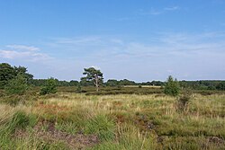
Heathland at the Hoge Kempen National Park
There are numerous protected areas in Belgium with a wide variety of types, protection levels and sizes. The below list gives an overview of the most important protected areas. (Full article...) -
The Ulyanovsk Oblast in Russia contains about 118 protected natural areas. (Full article...)
-

Entrance to Tanintharyi Nature Reserve.
This list of protected areas of Myanmar includes national parks, wildlife sanctuaries and botanical gardens that were established since 1927. (Full article...) -
This is a list of protected areas in Bulgaria which includes 3 national parks, 11 nature parks and 55 nature reserves. The national policy for governing and management of the protected areas is implemented by the Ministry of Environment and Water. The first nature park in Bulgaria and the Balkan Peninsula is Vitosha Nature Park, established in 1934. All of the nationally protected areas in Bulgaria are also part of the Natura 2000 network of protected natural areas in the territory of the European Union. Bulgaria has some of the largest Natura 2000 areas in the European Union covering 33.8% of its territory.
- Parks and reserves in italic letters are part of Global 200 ecoregions.
-
Protected areas of Norway include:
About 17 percent of the mainland of Norway is protected. Of this, ca. 8.3 percent is national parks, 1.3 percent is nature reserves and 4.7 percent otherwise protected. (Full article...) -
Greece is characterized by an extremely fragmented, rugged landscape hosting a great diversity of ecosystems and an outstanding biodiversity. Almost 5% of its extensive coastline consists of ecologically sensitive wetlands. Two thirds of the total population live no further than 2 km from the coast and most of the important urban centers are coastal, while almost all of the tourist infrastructure is divided among islands and the coastal mainland. (Full article...)
-
The country of Burundi in Africa has the following national parks and other protected areas. (Full article...)
-
This is a list of protected areas of Saudi Arabia, some of which are managed by the Saudi Wildlife Authority.:
- At-Taysiyah Protected Area
- Jabal Shada Nature Reserve
- Majami'al-Hadb Protected Area
- Nafud al-'Urayq
- Raydah Natural Reserve
- 'Uruq Bani Ma'arid
- Saja Umm Ar-Rimth Natural Reserve
- Harrat al-Harrah Protected Area
- Al-Khunfah Natural Reserve
- Ibex Reserve Protected Area
- Mahazat as-Sayd Protected Area
- Umm al-Qamari Islands
- Al-Tubayq Natural Reserve
- Farasan Islands Protected Area
- Jubail Marine Wildlife Sanctuary
- Jabal Aja Protected Area
- Wadi Turabah Nature Reserve
-
</mapframe>
There are four categories of protected areas in India, constituted under the Wildlife Protection Act, 1972. Tiger reserves consist of areas under national parks and wildlife sanctuaries. There are 53 tiger reserves in India. As of January 2023,[update] the protected areas of India cover 173,629.52 square kilometres (67,038.73 sq mi), roughly 5.28% of the total geographical area of the country. (Full article...) -
Protected areas of Slovenia include one national park (Slovene: narodni park), three regional parks (regijski park), several natural parks (krajinski park), and hundreds of natural monuments (naravni spomenik) and monuments of designed nature (spomenik oblikovane narave). They cover about 12.5% of the Slovenian territory. Under the Wild Birds Directive, 26 sites totalling roughly 25% of the nation's land are "Special Protected Areas"; the Natura 2000 proposal would increase the totals to 260 sites and 32% of national territory. (Full article...)
-
Papua New Guinea is home to several protected areas, which receive protection because of their environmental, cultural or similar value.
The total area of Papua New Guinea protected territories is 14,330 km2 (5,530 sq mi), which amounts to approximately 3.07% of the country's territory. The total number of protected areas as 2018 is 71. (Full article...) -
Protected areas of West Bengal cover 4% of the state area. Forests make up 14% of the geographical area of West Bengal, which is lower than the national average of 33%. West Bengal has a wide variety of fauna, including Bengal tigers, Indian leopards, sloth and Himalayan black bears, chital and sambar (deer), Indian boars, pygmy hogs, Indian elephants, Indian peafowl, great Indian hornbills, Eurasian spoonbills, brahminy ducks, king and Indian cobras, white-lipped pit viper, Indian and reticulated pythons, mugger crocodiles, saltwater crocodiles, gharials, and many more. A huge montane forest, Dooars, is situated in the Northern West Bengal districts of Alipur Duar, Darjeeling, and Kalimpong. Part of the world's largest mangrove forest, Sundarbans, is located in southern West Bengal.
There are 6 national parks and 15 wildlife sanctuaries in West Bengal. (Full article...) -

Vegetation outside Goz Beïda
The wildlife of Chad is composed of its flora and fauna. West African lions, African buffalo, hippopotamuses, Kordofan giraffes, antelopes, African leopards, cheetahs, hyenas, bush elephants, and many species of snakes are found there, although most large carnivore populations have been drastically reduced since the early 20th century. Elephant poaching, particularly in the south of the country in areas such as Zakouma National Park, is a severe problem. (Full article...)


Selected world maps
-
 A plate tectonics map with volcano locations indicated with red circles
 -
 Mollweide projection of the world
 -
 United Nations Human Development Index map by country (2016)
 -
 The Goode homolosine projection is a pseudocylindrical, equal-area, composite map projection used for world maps.
 -
 Index map from the International Map of the World (1:1,000,000 scale)
 -
 The world map by Gerardus Mercator (1569), the first map in the well-known Mercator projection
 -
 Time zones of the world
 -
 Only a few of the largest large igneous provinces appear (coloured dark purple) on this geological map, which depicts crustal geologic provinces as seen in seismic refraction data
 -
 1516 map of the world by Martin Waldseemüller


World records
- List of Olympic records in athletics
- List of world records in athletics
- List of junior world records in athletics
- List of world records in masters athletics
- List of world youth bests in athletics
- List of IPC world records in athletics
- List of world records in canoeing
- List of world records in chess
- List of cycling records
- List of world records in track cycling
- List of world records in finswimming
- List of world records in juggling
- List of world records in rowing
- List of world records in speed skating
- List of world records in swimming
- List of IPC world records in swimming
- List of world records in Olympic weightlifting
Topics

Continents of Earth | ||||||||
|---|---|---|---|---|---|---|---|---|
| ||||||||
| ||||||||
| ||||||||


| Cenozoic Era (present–66.0 Ma) |
| ||||||||||||
|---|---|---|---|---|---|---|---|---|---|---|---|---|---|
| Mesozoic Era (66.0–252 Ma) |
| ||||||||||||
| Paleozoic Era (252–539 Ma) |
| ||||||||||||
| Proterozoic Eon (539 Ma–2.5 Ga) |
| ||||||||||||
| Archean Eon (2.5–4 Ga) | |||||||||||||
| Hadean Eon (4–4.6 Ga) | |||||||||||||
ka = kiloannum (thousand years ago); Ma = megaannum (million years ago); Ga = gigaannum (billion years ago). See also: Geologic time scale • | |||||||||||||
| Locations | ||
|---|---|---|
| Related | ||

| |||||||||||||||||||
| |||||||||||||||||||
| |||||||||||||||||||
Economic classification of countries | |||||
|---|---|---|---|---|---|
| Three-World Model | |||||
| Gross domestic product (GDP) |
| ||||
| Gross national income (GNI) | |||||
| Wages | |||||
| Wealth | |||||
| Other national accounts | |||||
| Human development | |||||
| Digital divide | |||||
| Net international investment position (NIIP) | |||||
| Technological |
| ||||
|---|---|---|---|---|---|
| Sociological | |||||
| Ecological |
| ||||
| Biological |
| ||||
| Astronomical | |||||
| Eschatological |
| ||||
| Others |
| ||||
| Fictional | |||||
| Organizations | |||||
Categories

Wikimedia
The following Wikimedia Foundation sister projects provide more on this subject:
-
 Commons
Free media repository -
 Wikibooks
Free textbooks and manuals -
 Wikidata
Free knowledge base -
 Wikinews
Free-content news -
 Wikiquote
Collection of quotations -
 Wikisource
Free-content library -
 Wikispecies
Directory of species -
 Wikiversity
Free learning tools -
 Wikivoyage
Free travel guide -
 Wiktionary
Dictionary and thesaurus


